This item has been sold, but you can enter your email address to be notified if another example becomes available.


|
||

|

|
|

|
Stock# 43738
Description
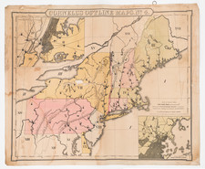
Interesting map of New England and the Canadian Coastline, illustrating the region relating to the so-called Vinland map.
The Vinland map is believed by some to be a 15th Century world map, showing information regarding the Norse exploration of America. For a more thorough essay on the map, please visit the following link: www.econ.ohio-state.edu/jhm/arch/vinland/vinland.htm
Condition Description
Minor loss at bottom left corner.
![[ Cape Cod to Acadia ] Pas-Kaart Vande Zee Kusten inde boght van Niew Engeland Tusschen de Staaten Hoek en C.de Sable . . .](https://storage.googleapis.com/raremaps/img/small/94453.jpg)