|
||

|

|
|

|
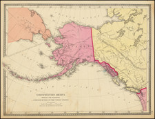
Early detailed map of the passage between Asia and the NW Coast of America, including nice topographical details and the day by day tracks of Cook through the region in 1778-79.
Large decorative compass rose. An important early map of the region.
Rigobert Bonne (1727-1794) was an influential French cartographer of the late-eighteenth century. Born in the Lorraine region of France, Bonne came to Paris to study and practice cartography. He was a skilled cartographer and hydrographer and succeeded Jacques Nicolas Bellin as Royal Hydrographer at the Depot de la Marine in 1773. He published many charts for the Depot, including some of those for the Atlas Maritime of 1762. In addition to his work at the Depot, he is best known for his work on the maps of the Atlas Encyclopedique (1788) which he did with Nicholas Desmarest. He also made the maps for the Abbe Raynals’ famous Atlas de Toutes Les Parties Connues du Globe Terrestre (1780).
More than his individual works, Bonne is also important for the history of cartography because of the larger trends exemplified by his work. In Bonne’s maps, it is possible to see the decisive shift from the elaborate decorations of the seventeenth century and the less ornate, yet still prominent embellishments of the early to mid-eighteenth century. By contrast, Bonne’s work was simple, unadorned, and practical. This aesthetic shift, and the detail and precision of his geography, make Bonne an important figure in mapping history.

![[Russia] Generalis Totius Imperii Moscovitici Novissima Tabula Magnam Orbis Terrarum partem a Polo Arctico usq[ue] ad mare Iaponicum, et Chinae Septentrionalis confinia exhibens cum Viz Czaricae nuper Legationis ex urbe Moscua per universum Tartariam ad magnu[m] Chinae Imperateruem ex conatibus . . .](https://storage.googleapis.com/raremaps/img/small/65778.jpg)
![Carte des nouvelles decouvertes dresseee par Phil. Buache… [with] Extrait d'une Carte Japonoise de l'Univers apportee en Europe par Kaempfer . . . [Bay of the West]](https://storage.googleapis.com/raremaps/img/small/84038.jpg)