|
||

|

|
|

|
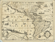
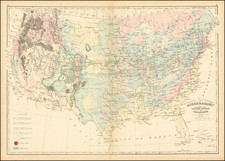
Striking large map of North America in attractive full wash colors, from the French edition of Carey & Lea's Atlas of America, one of the most important American Atlases of the early 19th Century. The map includes a 54-40 or fight border with Canada, and depicts Mexico immediately after its Independence from Spain (and still including Texas and Upper California).
The cartography of Lewis & Clark, Humboldt and Long, are very much in evidence. The mythical river connecting the Pacific with the Rocky Mountain region is still shown. A Russian Company near San Francisco is noted. The missions of Upper California are named and shown, and there is marvelous detail in Russian America (Alaska) and throughout the Transmississippi West. A nice example of this beautiful map.
Jean Alexandre Buchon (1791-1849) was a French scholar and historian. Born as the French Revolution raged, Buchon was dedicated to recovering France’s history in order to help the country heal and grow. He gathered French stories and published them as part of Collection des chroniques nationales franciases ecrites en langue vulgaire, du XIe au XVIe siècle (4 vols, 1824-1829). He also compiled and published an exploration collection and several histories, particularly about medieval France.
For geography, his most important contribution was publication of the French edition of Carey & Lea’s American Atlas in 1825. Each page of the atlas includes highly detailed text about the state or territory depicted, as well as a map of the area. The French edition is generally considered in high regard as compared to other editions, as it has quality paper and superior engraving.