


|
||

|

|
|

|
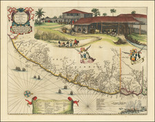
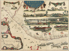
Nice example of 1 sheet of the Georg Marcgraf - Johannes Blaeu wall map of Brazil, the most important map of Brazil published in the 17th Century
The present example of the map consists of the right center sheet of the map published by Hugo Allard and dated 1659 (although at least one writer refers to it as the 1657 edition, perhaps erroneously, as original 7 has been changed to a 9 rather crudely). The dedication to Johannes Maruitiius of Nassau is dated 1644 and 1646. The map was first pubilshed by Blaeu in 1646-47. This Allard edition is apparently the second edition of the map. A later edition was issued by Clemente de Jonghe in 1664. The original manuscript in 9 sheets is in the collection of the Harvard University Library.
The Hugo Allard edition of the map was unknown until 1983, when a complete copy of the map appeared at Sothebys in London, where it was purchased by Nico Israel. The catalog description for the map was as follows:
Not traced in the British Library: there was an issue bearing the imprint of Johannes Blaeu (1657) [in the Klencke Atlas], and a later issue (perhaps a close copy?) with the imprint of Clement de Jonghe (1664). The present example shows what appears to be a correction of the imprint date from 1657 to 1659. Some of the individual sheets have a very close affinity with the maps in Caspar Barlaeus' Rerum per Octennium in Brasilia (1647). This impressive map is embellished with numerous vignettes showing battle scenes, natural history subjects and a sugar mill, many after Frans Post, who accompanied Maurits of Nassau to Brazil in his campaigns in the Dutch colonies in Brazil (see Maurits de Braziliaan (The Hague 1953)).
Georg Marcgraff (1610-1644) was a German astronomer and naturalist. In 1637, he was appointed astronomer of a company being formed to sail to the Dutch colony in Brazil. He accompanied Willem Piso, a physician and the newly appointed governor of the Dutch possessions in that country. Later, Marcgraf worked for Johannes Maruitiius of Nassau, who allowed Marcgraf to explore and later mapa considerable part of Brazil. He arrived in Brazil in early 1638 and undertook the first zoological, botanical, and astronomical expedition there, exploring various parts of the colony to study its natural history and geography. He later explored the coast of Guinea, where he died in 1644
During his time in Brazil, Marcgraf and Cornelis Goliath created a map of Brazil, under the sponsorship of Johan Maurits, which was completed in 1643. This map remained the most important ad accurate cartographic representation of Brazil until the 19th century. The Marcgraf Map-actually a series of maps-is illustrated with engravings that offer panoramas of Brazilian life. The illustrations in the map were probably based directly on the drawings of Frans Post, during his 7 years in Brazil as part of the Dutch occupation of the region.
The map was first published as a 9 sheet wall map by Johannes Blaeu and In 1643. The decorative embellishements were popularized by Barleus and Blaeu in a series of maps published in Amsterdam. The full map is of the utmost rarity and is known only in a few examples.
This link shows one of three known examples of the Blaeu edition of Marcgraf's map: imagesonline.bl.uk/index.php?service=search&action=do_quick_search&language=en&q=%2322179
This link shows an example of the map published by Clement de Jonghe in 1664: www.maritiemdigitaal.nl/ index.cfm?event=search.getdetail&id=100105577.
The present example was engraved by Hugo Allard in 1659 (although it is possible that an earlier edition of 1657 was published). A quick comparision of the two maps shows that the Allard edition is almost certainly from a different set of plates than the De Jonghe edition of 1664, as there are subtle but significant differences in each of the plates in the placement of the text, rhumblines and annotations.
The original wall map by Blaeu is apparently known in 3 examples (British Library, Berlin and Rostock). The British Library copy of the Blaeu edition is dated 1657.
The Clemente De Jonghe edition (1664) is known in 3 copies (Briitish Library, Bibliotheque Nationale de France, Maritime Museum Rotterdam).
Hugo (or Huych) Allard (or Allardt) (1627–1684 or '91) was a draughtsman, engraver, and painter during the Dutch Golden Age of cartography. Based in Tournai and Amsterdam, he was the founder of a prominent family of Dutch mapmakers, publishers, and print sellers. Allard set up his cartography business around 1645, and his first works were mostly reissues of earlier maps. Although not as prominent as the Blaeu family or Henricus Hondius and Jan Janssonius, Hugo Allard’s work, from about 1640 to 1680, is considered to be just as fine in quality. His output was relatively small, and his maps were mostly published as loose, separate issues, but they were well-designed and finely engraved. After Allard’s death, he left his business to his son, Carel. There is some confusion about when he died; some sources state 1684, others say 1691.
Georg Marcgraff (1610-1644) was a German astronomer and naturalist. In 1637, he was appointed astronomer of a company being formed to sail to the Dutch colony in Brazil. He accompanied Willem Piso, a physician and the newly appointed governor of the Dutch possessions in that country. Later, Marcgraf worked for Johannes Maruitiius of Nassau, who allowed Marcgraf to explore and later mapa considerable part of Brazil. He arrived in Brazil in early 1638 and undertook the first zoological, botanical, and astronomical expedition there, exploring various parts of the colony to study its natural history and geography. He later explored the coast of Guinea, where he died in 1644
During his time in Brazil, Marcgraf and Cornelis Goliath created a map of Brazil, under the sponsorship of Johan Maurits, which was completed in 1643. This map remained the most important ad accurate cartographic representation of Brazil until the 19th century. The Marcgraf Map—actually a series of maps—is illustrated with engravings that offer panoramas of Brazilian life. The illustrations in the map were probably based directly on the drawings of Frans Post, during his 7 years in Brazil as part of the Dutch occupation of the region.

![[Ilha da Santa Catarina to Bombinhas]](https://storage.googleapis.com/raremaps/img/small/59598.jpg)

![[Ilha da Santa Catarina to Bombinhas]](https://storage.googleapis.com/raremaps/img/small/59595.jpg)