- Antique Maps
- North America
- Canada
- Old and antique maps of Western Canada for sale. Our authentic Western Canada map inventory features antique maps of Canada from the period of the earliest European exploration by Vancouver, Russian explorers, Malaspina, and Mackenzie. Our map inventory typically includes antique and vintage city views and plans of Victoria and Vancouver, as well as maps of the Yukon, British Columbia, Alberta, etc. Vintage pictorial maps of Western Canada are also for sale.
- Sketch Map of Salmon River Gold Field Yukon...
Map Maker
Title
Sketch Map of Salmon River Gold Field Yukon Territory To accompany Summary Report by R.G. McConnell B.A. 1901
Publication Place / Date
n.p. / 1901
Image Dimensions
5.5 x 7 inches
Color
Color
Condition
VG+
Stock# 43477
$ 125.00
Map Maker
Authenticity Guarantee
All of our maps are authentic antique maps, printed or drawn on or about the date shown in the description. In rare instances when we offer facsimiles, we will specifically describe the map as a later facsimile and include the date of publication. Certificates of Authenticity are included with each item.
Map Maker
Fast, Global Shipping
Last year we shipped over 4,500 antique maps to more than 50 countries. Maps are shipped Monday through Friday year-round. If an order is received before 2 PM PST, we will ship the order that day. If an order is received after that time, we will ship the next day. We ship maps either flat in custom packages or in specially ordered thick tubes. Shipping rates are provided as part of the checkout process.
Description
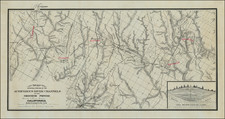
Detailed map of the Salmon River Gold Field, as surveyed by the Geological Survey of Canada.
The map provides a highly detailed description, overlaid on a topographical map of the South Fork of Big Salmon River.
The 1881 on strike on the Big Salmon River was the first payable quantity of placer gold discovered in the Yukon.
Related Categories
Related Items