|
||

|

|
|

|
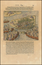
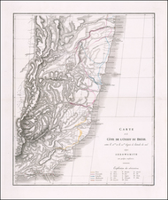
Fascinating early map, showing the French Colony in the Rio De Janeiro area, estabished in 1555.
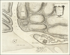
This map is based on the voyages of the vice-Admiral Nicolas Durand de Villegagnon and of the explorer and writer, Jean de Leri. The map names the Mer du Bresil (Sea of Brazil) and the "Riviere de Ganabara autrement Rio Janeiro" (Ganabara River otherwise called Rio Janeiroj). The mouth of the river shows seven islands with at least three inhabited by the colonists. There are a total of twenty five marked villages, towns, and or fortifications. Six of them are on the islands in the bay, the rest are around the bay, and only one is below the Capricorn line marked on the map. The writing along the river says river of fresh water.
The colony lasted from between 1555 and 1567, and had control over the coast from Rio de Janeiro to Cabo Frio. It was located at the mouth of the river, at Guanabara Bay, current day Rio de Janeiro. This colony soon became a haven for Huguenot refugees persecuted in mainland France.
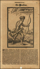
On November 1, 1555, French vice-admiral Nicolas Durand de Villegaignon, a Catholic knight of the Order of Malta, led a small fleet of two ships and 600 soldiers and colonists, and took possession of the small island of Serigipe in the Guanabara Bay, in front of present-day Rio de Janeiro, where they built a fort named Fort Coligny. The admiral would later use the colony in order to help the Huguenots find a refuge against persecution. The Portuguese took little notice of this landing and Villegagnon called for more colonists. Three more ships landed with soldiers and colonists. Jean de Leri accompanied a small group of fellow Huguenots to their new colony on an island in the Bay of Rio de Janeiro, but on arrival, Villegaignon contested the Huguenots' beliefs and persecuted them.
After eight months the Huguenots left their colony and survived for a short time on the mainland, living amongst the Tupinamba Indians.
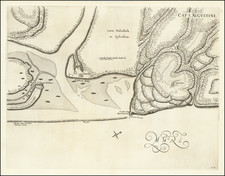
The Portuguese government ultimately decided to expel the French. With a fleet of 26 warships and 2,000 soldiers, on March 15 1560, the Portugese attacked and destroyed Fort Coligny. They were unable to drive off the inhabitants and defenders, because they escaped to the mainland with the help of the Native Brazilians, where they continued to live and to work . Being so far from France there was still religious tension that existed between French Huguenots and Catholics. This disgusted Admiral Villegaignon and so he returned to France in 1558.
Later, Mem de Sá (the new governor-general of Brazil) ordered his nephew, Estácio de Sá to assemble a new attack force. Estácio de Sá would found the city of Rio de Janeiro on March 1, 1565, and would fight the French for two more years. Helped by a military reinforcement sent by his uncle, on January 20, 1567, de Sa finally defeated the French forces and decisively expelled them from Brazil.
Pierre Duval (1618-1683) was a French geographer, cartographer, and publisher who worked in Abbeville and Paris during the seventeenth century. He was born in the former city, in northeast France, before moving to Paris. Duval was the nephew of the famous cartographer Nicolas Sanson, from whom he learned the mapmaker's art and skills. Both men worked at the royal court, having followed the royal request for artists to relocate to Paris. In addition to numerous maps and atlases, Du Val's opus also includes geography texts. He held the title of geographe ordinaire du roi from 1650 and died in 1683, when his wife and daughters took over his business.