|
||

|

|
|

|
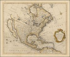
Rare map of North America, published in Madrid by Tomas Lopez.
Among its more interesting features, this is one of the few maps that refers to Texas as "Nueva Filipinas." Nuevas Filipinas and Nuevo Reino de Filipinas were secondary names given to the area of Texas above the Medina River at the time of Domingo Ramón's expedition of 1716. Although less popular than the name Texas, Nuevas Filipinas remained part of the province's official name throughout the colonial period. Antonio Margil de Jesús evidently first used the name Nuevas Filipinas in a letter to the viceroy dated July 20, 1716. In it he voiced the hope that with the king's patronage it might be possible to secure "for the greater glory of God and the name of our catholic Monarch another new Philippines" among the Hasinai. Later, in his journal, Governor Alarcón calls himself "Governor and Lieutenant Captain General of the Provinces of Coahuila, New Kingdom of the Philippines Province of the Texas." A modification of this title appears in his memorial of services to the crown, in which he refers to himself as governor and lieutenant captain general of the Province of the Texas and New Philippines. Although Nuevas Filipinas appeared regularly on documents during the next forty years or so, if fell out of use toward the end of the eighteenth century.
One of the earliest Spanish Language maps to name and locate the United States (Estados-Unidos). The name "Providencia" is also given as one of the states of the United States. It is difficult to know with certainty whether this was a reference to the attempt to make Providence the Capital of the United States, as both Charleston and Philadelphia are also listed as Capitals.
Map publishing in Spain began in a systematic fashion in the second half of the 18th Century, as Spain increasingly embraced the enlightenment and recognized he need for the creation of a more robust domestic publishing business. The most important mapmaker in Spain in the second half of the 18th Century was Tomas Lopez. Lopez had official access to Spain's remarkable archive of manuscript material and over time, produced an impressive array of large and small format maps.
Tomás López de Vargas Machuca (1730-1802) was one of Spain’s most prominent cartographers in the eighteenth century. He was born in Toledo but studied at the Colegio Imperial in Madrid, where he focused on mathematics, grammar, and rhetoric. Along with a small group of colleagues, in 1752 the Spanish government sent López for training in Paris with the renowned geographer Jean Baptiste Bourguignon d’Anville. When he returned to Spain he was named Geógrafo de los dominios de Su Magestad and put in charge of the geographic collections of Charles III. He published many maps, including his fascinating maps of the Americas, and a variety of geography manuals. Some of his most famous maps are of the Iberian Peninsula, part of his large project to create a majestic atlas of Spain. Unfinished in his lifetime, López's children published the Atlas Geográfico de España (Geographical Atlas of Spain) in 1804. It was republished in 1810 and 1830.
![[Educational Map] North America](https://storage.googleapis.com/raremaps/img/small/68773.jpg)
![Colton's North America [Wyoming attached to Dakota]](https://storage.googleapis.com/raremaps/img/small/98345.jpg)
![[First State of the Popple Key Sheet] A Map of the British Empire in America with the French and Spanish Settlements adjacent thereto by Hen. Popple.](https://storage.googleapis.com/raremaps/img/small/92714.jpg)