|
||

|

|
|

|
Decorative example of one of the most important charts of Boston Harbor from the Revolutionary War period.
De Barres' remarkable chart of Boston Harbor is a highly important Revolutionary War map depicting details relating to the Siege of Boston
This is one the most important maps contained in Des Barres'
Atlantic Neptune, and one of the most significant maps of the Revolutionary War. The map provides a meticulous record of Boston at the beginning of the war, covering the area from the environs of the city out into the open waters of Massachusetts Bay. The map is a working sea-chart, focused upon features such as depth soundings, indicated by detailed lines and based on surveys by Samuel Holland and George Callendar, and the navigable channels between the harbor's numerous shoals, which are delicately outlined in stipple-engraving. Holland's original manuscript map is today preserved in the British Hydrographic Library at Taunton, Somerset. The present map shows the city of Boston, with its streets carefully outlined, occupying a pear-shaped peninsula, a position that would soon prove precarious to its British defenders in the escalating conflict.
This edition has been significantly updated to show both topographical improvements and additional fortifications, etc., associated with the siege of Boston.
Joseph Frederick Wallet Des Barres was born in Switzerland, where his Huguenot ancestors had fled following the repeal of the Edict of Nantes. He studied under the great mathematician Daniel Bernoulli at the University of Basel, before immigrating to Britain, where he trained at the Royal Military College, Woolwich. Upon the outbreak of hostilities with France in 1756, he joined the British Royal American Regiment as a military engineer. He came to the attention of General James Wolfe, who appointed him to join his personal detail. During this period he also worked with the legendary future explorer James Cook on a monumental chart of the St. Lawrence River.
Upon the conclusion of the Seven Years War, Britain's empire in North America was greatly expanded, and this required the creation of a master atlas featuring new and accurate sea charts for use by the Royal Navy. Des Barres was enlisted to survey the coastlines of Nova Scotia, Newfoundland, and the Gulf of St. Lawrence. With these extremely accurate surveys in hand, Des Barres returned to London in 1774, where the Royal Navy charged him with the Herculean task of producing the atlas. He was gradually forwarded the manuscripts of numerous advanced surveys conducted by British cartographers in the American Colonies, Jamaica and Cuba, of which the present map is based on the work of Samuel Holland, conducted in the 1760s. The result was The Atlantic Neptune, which became the most celebrated sea atlas of its era, containing the first systematic survey of the east coast of North America. Des Barres's synergy of great empirical accuracy with the peerless artistic virtue of his aquatint views, created a work that "has been described as the most splendid collection of charts, plates and views ever published" ( National Maritime Museum Catalogue). '
The Neptune eventually consisted of four volumes and Des Barres's dedication to the project was so strong that often at his own expense he continually updated and added new charts and views to various editions up until 1784, producing over 250 charts and views, many appearing in several variations. All of these charts were immensely detailed, featuring both hydrographical and topographical information, such that in many cases they remained the most authoritative maps of the regions covered for several decades. Following the completion of The Neptune, Des Barres returned to Canada, where he remained for a further forty years, becoming a senior political figure and a wealthy land owner, living to the advanced age of 103.
Joseph Frederick Wallet Des Barres (1721-1824) was born in either Paris or Basel, Switzerland, to a Hugueont family. He studied under the great mathematician Daniel Bernoulli at the University of Basel before immigrating to Britain, where he trained at the Royal Military College, Woolwich.
Upon the outbreak of hostilities with France in 1756, he joined the British Royal American Regiment as a military engineer. He came to the attention of General James Wolfe, who was impressed with his charting ability. During this period, he also worked with the legendary future explorer, James Cook, on a monumental chart of the St. Lawrence River.
Des Barres is best known for the Atlantic Neptune, was a remarkable, multi-volume set of sea charts and coastal views prepared from recent surveys, some of which were overseen by Des Barres in Nova Scotia after the Seven Years’ War. The maps, charts, and views were prepared under the supervision of Des Barres and employed as many as twenty engravers and assistants. They were produced over the course of a decade, from 1774 to 1784, in time to be used by the Royal Navy in the American Revolution.
After the Revolution, Loyalists were resettled throughout Canada. As part of this process, a new colony was created by separating Cape Breton from Nova Scotia. Des Barres, who already owned extensive lands in the Maritimes, served as lieutenant governor of Cape Breton Island from 1784 to 1787. He later served as governor of Prince Edward Island from 1804-1812.
Des Barres lived an exceptionally long life, even by today's standards, finally dying at age 102. Des Barres' funeral was held at St. George's Round Church in 1824 and he is buried in Halifax.
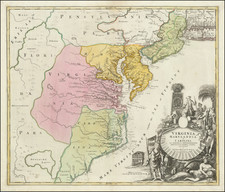
![A New and Exact Map of the Dominions of the King of Great Britain on ye Continent of North America . . . [Beaver map]](https://storage.googleapis.com/raremaps/img/small/101277.jpg)

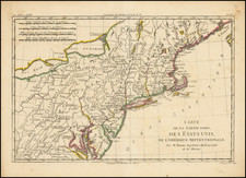
![[British Colonies in America] Carte Qui Contient Une Description Des Iles & Terres Que Les Anglois . . .[maps of Chesapeake, Carolinas, New England, Bermuda, Gulf Coast, Jamaica, Barbadoes & Canada]](https://storage.googleapis.com/raremaps/img/small/61480.jpg)