
This item has been sold, but you can enter your email address to be notified if another example becomes available.


|
||

|

|
|

|
Stock# 4293
Description
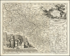
Very scarce regional map, showing area bounded by Dniester, Bruth and Moldova Rivers and including Sutzawa, Czernowitz, Sireth, Chotin, Kaminiecc Podolsky, Kyataigrod, Grodeck Mikohtschin, Hokurasza, Baja and a portion of Galitzia. Shows rivers, roads, towns, castles, forests, lakes and a host of other details. Quite possibly the most detailed map of this region to appear in an 18th Century Atlas. From Von Reilly's exceedingly scarce Grosser Deutscher Atlas. Von Reilley & Schaembl led a revival of map making in Vienna in the late 18th Century which included this and several other sought after works.
![[Soviet Union] Our Country -- From Wooden Plough To Sputnick](https://storage.googleapis.com/raremaps/img/small/47092.jpg)
![[Russia] Generalis Totius Imperii Moscovitici Novissima Tabula Magnam Orbis Terrarum partem a Polo Arctico usq[ue] ad mare Iaponicum, et Chinae Septentrionalis confinia exhibens cum Viz Czaricae nuper Legationis ex urbe Moscua per universum Tartariam ad magnu[m] Chinae Imperateruem ex conatibus . . .](https://storage.googleapis.com/raremaps/img/small/65778.jpg)