|
||

|

|
|

|
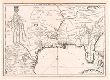
Scarce map of the Great Lakes and Upper Mississippi region, with nice coverage of the Missouri River Valley to Kansez and Ft. d'Orleans.
Extends east to include Lake Ontario, North to James Bay and Southeast to Philadelphia. The map shows numerous French forts throughout, along with substantial Indian details. Chicagon [sic] is named. One of the best large format maps of the region during the latter part of the 18th Century, based upon D'Anville's map of North America.
Paolo Santini (1729-1793) was an Venetian engraver known especially for his religious prints and fine cartographic engravings. He published in Venice and may have a been a member of the clergy. In his maps, he largely adopted and adapted the work of his French counterparts, especially the brothers de Vaugondy.