This item has been sold, but you can enter your email address to be notified if another example becomes available.


|
||

|

|
|

|
Stock# 42507
Description
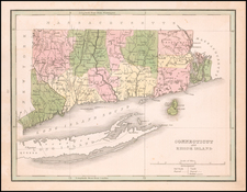
Detailed map of Connecticut, Long Island and most of Rhode Island, hand colored by townships and showing towns, railroads, roads, post offices, stations, etc.
One of the best commercial atlas maps of the era. From one of the leading American map publisher of the 1870s.
O.W. Gray Biography
O. W. Gray was a publishing firm based in Philadelphia. Later, they published as O. W. Gray & Son. They published atlases in the late nineteenth century. Gray's National Atlas was one of the most successful commercial ventures of the 1870s and one of the last to employ hand coloring on maps.

![[Portland & Cape Elizabeth to Moskito Island -- Centered on Kennebec River]](https://storage.googleapis.com/raremaps/img/small/50079.jpg)