


|
||

|

|
|

|
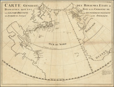
Interesting manuscript map of North America, issued shortly after the conclusion of the American Revolution.
Cartographically, the map pre-dates Lewis & Clark's discoveries and the coastal expeditions of Vancouver & La Perouse.
Cook's River is shown as are the discoveries of MacKenzie in the Arctic regions, fixing the date of the map as post 1780.
Other interesting features include the retention of the name New Albion for California, the retention of the River of the West (mythical) and the area in the Arctic Regions of Canada identified as Unexplored Regions.
A curious addition is the name "Fox Islands" for the Aleutian Islands. In reality, the Fox Islands comprise a very small part of the Aleutian chain. The Fox Islands were discovered in 1759-62 by the Russian navigator S. Glotov. Their name is associated with the abundance of foxes on the islands at that time.
One of the few 18th Century manuscript maps of North America we have seen on the market.
![America [Manuscript Map Showing the Sea of the West!]](https://storage.googleapis.com/raremaps/img/small/41297dm.jpg)

![A New Mapp of America Septentrionale . . . 1669 [California shown as an island]](https://storage.googleapis.com/raremaps/img/small/94304.jpg)