|
||

|

|
|

|
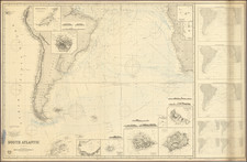
First edition of this rare separately issued Spanish Sea Chart of the Coast of Chile.
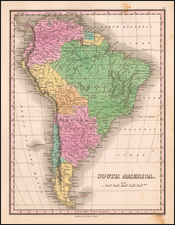
The chart covers the majority of the Chilean coastline from just north of Cobija to south of Concepcion. Place names are confined to the coast, with only the city of Santiago appearing inland.
The chart incluces three coastal views. The routes of the twin corvettes of the Spanish Navy, Descubierta and Atrevida, are depicted, along with miniature pointing hands to identify the direction of their voyage.
The ships were built for the Malaspina Expedition. Commanded by Alessandro Malaspina and José de Bustamante y Guerra. Malaspina's expedition was the most important voyage of discovery dispatched by Spain in the 18th century. It had two primary goals, the first being to increase geographic and scientific knowledge in general, the second being to check on the status of Spain's vast empire, especially along the west coast of North America, where the Russians and the British were expanding their influence. Modeled after the voyages of James Cook, the Malaspina expedition was conducted in a highly scientific manner. Numerous scientists from many fields were among the crew. Indigenous peoples, such as the Tlingit and Tongan, were studied by the expedition's ethnographers.
The Descubierta and Atrevida sailed from Cadiz on July 30, 1789, stopping first at Montevideo on the Río de la Plata, then sailing south along the coast of Patagonia and visiting the Falkland Islands (Islas Malvinas). After rounding Cape Horn the expedition stopped at several Chilean ports and surveyed the Juan Fernández Islands. The two corvettes sailed north separately, surveying and mapping the coast between Peru and Mexico, where they arrived at the end of March 1790, before heading north toward California and Alaska.
This map was created by Felipe Bauza and was published separately and in the very rare in the Atlas Maritimo Espanol by Spanish Hydrographical Department, whose seal appears at bottom left.
Drawn by Pedro Manuel Gangoiti and engraved by Juan Moreno Tejada.
The Dirección de Hidrografía, or the Directorate of Hydrographic Works, was established in 1797. Its roots were in the Casa de Contratación, founded in 1503 in Sevilla, which housed all the charts of the Spanish Empire and oversaw the creation and maintenance of the padrón real, the official master chart. The Casa, now in Cadiz, was shuttered in 1790, but Spain still needed a hydrographic body. In response, the Dirección was created in 1797. One of its first projects was the publication of charts from the Malaspina Expedition (1789-1794). The Dirección oversaw not only publication, but also surveying. The Dirección was abolished in the early twentieth century, when their work was distributed to other organizations.