


|
||

|

|
|

|
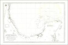
The Final Major Spanish Expedition To Chart The Coast of Yucatan and Environs
First Edition of Important Spanish sea chart of the Gulf Coast of Mexico and the Yucatan.
This is the rare first edition of the large-scale printed chart of the Coast of Mexico based upon actual soundings and explorations, which would later be re-issued in 1825 in the rare 14 chart Atlas y Portolano de la America Septentrional, published in Mexico in 1825, to commemorate Mexican independence from Spain.
First issued in 1808, the map would be revised in 1814, 1821, and 1846 and also issued as noted above in 1825 in Mexico City.
We locate only a single example of the map in the National Library of Spain.
The Dirección de Hidrografía, or the Directorate of Hydrographic Works, was established in 1797. Its roots were in the Casa de Contratación, founded in 1503 in Sevilla, which housed all the charts of the Spanish Empire and oversaw the creation and maintenance of the padrón real, the official master chart. The Casa, now in Cadiz, was shuttered in 1790, but Spain still needed a hydrographic body. In response, the Dirección was created in 1797. One of its first projects was the publication of charts from the Malaspina Expedition (1789-1794). The Dirección oversaw not only publication, but also surveying. The Dirección was abolished in the early twentieth century, when their work was distributed to other organizations.
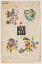
![(Mexican-Aztec Paintings) [Original watercolor of 4 Aztec Festival Deities]: Veitecuilitl, Miccailhhuitl, Festival of the Dead, Veymiccailhuitl, Ochpaniztl](https://storage.googleapis.com/raremaps/img/small/103004.jpg)
![(Texas) Denkschrift über eine Reise nach Nord-Mexiko, verbunden mit der Expedition des Obersten Donniphan, in den Jahren 1846 und 1847. Von Dr. A. Wislizenus. Aus dem Englischen übertragen von George M. von Ross. Mit einem wiffenschaftlichen Anhange und drei Karten. [Description of a voyage to northern Mexico connected with Colonel Doniphan's expedition in 1846 and 1847 By Dr. A. Wislizenus. Translated from the English by George M. von Ross. With a scholarly appendix and three maps.]](https://storage.googleapis.com/raremaps/img/small/88574.jpg)
![[Hand Drawn Map] Le Golfe de Mexique avec les Pays Circonvoisins](https://storage.googleapis.com/raremaps/img/small/91580.jpg)