|
||

|

|
|

|
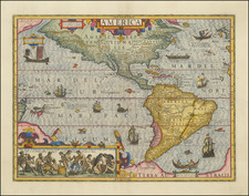
De Laet's Map of America from the second cartographic work dedicated to America.
Johannes De Laet's Nieuwe Wereldt ofte Beschrijvinghe van West-Indien was the second earliest compilation of maps to focus on America, after Cornelis Wyfliet's work of 1597. The map brought to the public the finely executed maps of Hessel Gerritsz. Gerritsz (1581-1632) was a Dutch engraver, cartographer and publisher, who is considered by some to have been "unquestionably the chief Dutch cartographer of the 17th century." (Johannes Keuning "Hessel Gerritsz" (1949) Imago Mundi Vol. 6, pp. 46-66).
The present work is De Laet's general map of America, providing a fine outline of America as known to the Dutch at the beginning of the 17th Century. The most interesting feature of this map is that although it is known that de Laet had seen maps of California as an island, he focused upon more reliable accounts, such as Herrera, in depicting a peninsular form. The map has the best west coast delineation to date. De Laet also does not speculate on the unknown polar regions and avoids any depiction of geographical detail regarding the speculative cartography of the Northwest Passage.
Johannes De Laet was an important participant in the founding of New Netherlands and a director of the Dutch West India Company, which sponsored its settlement. He also owned a large tract of land in the area of Albany. He therefore would have had access to surveys and information from Dutch colonists, which explains how he produced this fine map at such an early date.
![[ First State of the First Map of America ] Novae Insulae XVII Nova Tabula](https://storage.googleapis.com/raremaps/img/small/94609.jpg)
![Nova Tabula Americae Sic dictae ab Americo Vesputio Florentino qui Emmanuelis Portugalliae Regis auspicijs eam Anno 1497. (detectis prius A. 1492 a Christiphoro Columbo Hispanio la, Cuba, et Iamaica Insulis) prius ex Europaeis. . . [New Map of America, So Named by Americus Vespucci of Florence, Who Under the Auspices of King Emmanuel of Portugal First Detected it in the Year 1497 (Previously Discovered by Christopher Columbus of Spain in the Year 1492, on the Islands of Cuba and Jamaica), Prior to All European Maps. . .]](https://storage.googleapis.com/raremaps/img/small/93883.jpg)