|
||

|

|
|

|
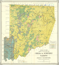
The original Promotional / Allocation Map of the Oto and Missouri Reservation, Oklahoma Territory.
This exceedingly rare publication shows on the map the actual allotment of lots within the Oto and Missouri Reservation in Oklahoma. The map identifies by name each allotment and names the 440 tribe members to whom 64,935.50 acres had been allotted. The map identifies the recipient of each allotment and exact location of the land. It also identifies 120 of the allotment recipients who had died since the original designations of eligibility for an allotment had been made.
Allotments of land for members of native tribes on the Oto-Missouri confederated reservation were mandated by Congress by Chapter 86 of the laws passed by the 53rd Congress, Second Session, on May 30, 1894. The law stipulated that land should be allotted to members of the tribe who were residing on the reservation lands as of March 3, 1881. The law also allowed for the subsequent sale of lands not allocated. Eligibility and allocation of the lands was determined and administered by the Dawes Commission. Ultimately, the lands of the Oto-Missouri and Ponca reservations were opened in 1904, after the allocations laid out here had been finalized and the interests of the heirs of deceased allocation holders adjudicated.
Kent Carter, " The Dawes Commission and the Allotment of the Five Civilized Tribes, 1893-1914" provides a broad overview of the situation.
In 1893, Congress authorized the establishment of an organization that became known as the Dawes Commission. The hope was that the commission could persuade the governments of the Five Civilized Tribes to negotiate themselves out of existence-an essential first step in implementing a policy of allotting land to each individual Indian. Allotment was supposed to promote assimilation into the dominant culture, clear the way for converting Indian Territory into a state, and satisfy powerful groups seeking opportunities for economic development and profit. However, when the tribal governments refused to cooperate in their own demise, Congress used its legislative power to abolish them and gave the Dawes Commission the almost impossible task of determining who was entitled to a share of land roughly the size of Indiana and worth millions of dollars.
This map provides an unmatched snapshot of the allotment process as it stood in the Oto-Missouri Reservation in 1902. In addition to containing a list of those individuals scheduled to receive allotments, it shows exactly where those allotments were located, with the names of the recipients shown on the lots on the map. The names present a mixture of native-based family names, e.g. Little Crow, Black Hawk, White Mule, etc., and non-tribal families such as Moore, Pickering and Tillman.
We can locate no other copies of this item in any institutional collection, although we have been informed that the Library of Congress and Yale both hold copies, the latter having been sold by this firm to Yale. It is not listed in OCLC and standard Internet searches generate no relevant results. We have located no auction or dealer catalogue offerings.
We have found only one Oklahoma allotment map for a different Indian Reservation offered for sale, an allotment map of the Kiowa, Comanche and Apache Reservation from 1901. This item, sold at the Siebert Sale in October, 1999, contained a map which showed only the general location of the allotment lands, not the names of the designees of particular parcels.
As part of the purchase of this map, we also acquired a copy of a similar map, also from 1902, for the Ponca Reservation.

![[ Hungarian Traveler In the California and the West with a Comanche and Wichita to Hungarian vocabulary ] Levelei Éjszakamerikából -- Tizenkét eredeti rajzok után készült kő- és egynéhány fametszettel. Közli Prépost István (Letters from North America)](https://storage.googleapis.com/raremaps/img/small/98502.jpg)