![[Battle of Moncontou] Victoria di chatolici contra Hugonoti By Anonymous / Lafreri School](https://storage.googleapis.com/raremaps/img/small/75053.jpg)


|
||

|

|
|

|
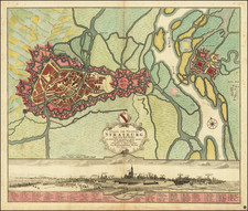
Rare plan of the Battle of Moncontou, France, by an early anonymous 'Laferi School' mapmaker.
Finely engraved battle plan depicting the Battle of Moncontour (near Poictou, France) in 1563.
The map shows the area of La Rochelle , Nantes , Tours and Limoges with Poitiers in the center .
The Battle of Moncontour was fought October 3, 1569, between the Catolic vorces of King Charles IX of France and the Huguenots, during Third War of the French Wars of Religion. Coligny broke off the Siege of Poitou, and joined with German allies, moved south, after the French were reinforced with mercenaries.
Henry, Duke of Anjou, attacked before Coligny could join with Gabriel, comte de Montgomery. The Swiss pikemen shattered the Huguenot landsknechts. 8,000 Huguenots surrendered.
![(Napoleon III) Camp De Chalons - Sur - Marne / Plan du Terrain Affecte au Camp et Des Terrains Environnans Leve par les Officieres du Genie Paris 1857 [with military movements added by hand]](https://storage.googleapis.com/raremaps/img/small/65093op.jpg)
![(Classical France) Tercia Europe Tabula [Third Map of Europe]](https://storage.googleapis.com/raremaps/img/small/101895.jpg)