|
||

|

|
|

|
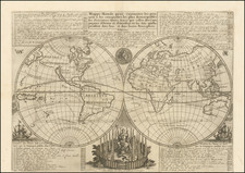
Unrestored example of the Giuseppe Longhi 12-sheet wall map of the world, published in Bologna circa 1675.
The map is drawn from Frederick De Wit's 12-sheet World map of 1660 (Shirley 422). De Wit's map was redrawn by Giuseppi Longhi in Bologna, circa 1680 and engraved by Carlo Scotti. It is possible that this is the same set of 12 sheets previously issued by Giovanni de Rossi in Rome in 1675 (one known example), but there are significant decorative revisions and the study of the map undertaken by Shirley showed no signs of erasures on the Longhi signed map.
The Longhi is significantly revised from the De Wit, including significant cartographic revisions including the addition of the Terra Iesso coastline between Japan and California in the North Pacific and the depiction of the Antarctic Coastline. The decorative embellishments have also been modified from De Wit and Rossi's editions, most notably, the replacement of the bust in the lower center below the hemispheres has been replaced with an armillary sphere.
De Wit (1629 ca.-1706) was a mapmaker and mapseller who was born in Gouda but who worked and died in Amsterdam. He moved to the city in 1648, where he opened a printing operation under the name of The Three Crabs; later, he changed the name of his shop to The White Chart. From the 1660s onward, he published atlases with a variety of maps; he is best known for these atlases and his Dutch town maps. After Frederik’s death in 1706, his wife Maria ran the shop for four years before selling it. Their son, Franciscus, was a stockfish merchant and had no interest in the map shop. At the auction to liquidate the de Wit stock, most of the plates went to Pieter Mortier, whose firm eventually became Covens & Mortier, one of the biggest cartography houses of the eighteenth century.
![[ Genesis / Creation ] De Schepping der Wereldt Volgens de Beschryving van Mozes. 1 Plaat [in set with] De Schepping der Wereldt Volgens de Beschryving van Mozes. 2. Plaat](https://storage.googleapis.com/raremaps/img/small/101543.jpg)