|
||

|

|
|

|
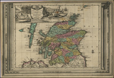
Nice example of this Lafreri School / anonymous map of Shetland Island, published circa 1560.
The map was published during a period in Italy where these maps are referred to as part of the "Lafreri School" of mapmakers. It is believed that the map was engaved by Bertelli in Venice, based upon an earlier map by Zenoi.
"The map of Estland is sometimes found pasted together with a map of Frisland. The latter is known in two states... (as above or) with the imprint of Petri de Nobilibus" (or Nobili)" (T.). The 5 towns depicted as small bird's-eye views; with nomenclature for these, the small circumjacent islands and also for 2 fjords (see above).
Antonio Lafreri
Antoine Lafréry, better known as Antonio Lafreri (1512-77) was born in Besançon. His earliest work in Rome dates to about 1544. From his workshop on the Via del Parione, he produced many important publications. In 1553, he founded a company with his mentor, Antonio Salamanca, which would operate until 1562. Thereafter, from 1562 to Lafreri's death in 1577, he conducted business under his own name.
While the present map proves that Lafreri was quite capable of devising his own first rate maps, he was primarily a dealer and publisher, rather than an artisan in his own right. He carried a vast stock of maps and prints made by other printers from both Rome and Venice. He became known for producing IATO (Italian-Assembled-To-Order) atlases, each unique composite atlases featuring a selection of fine Italian maps, made to the tastes of individual clients. Pre-dating Abraham Ortelius, these 'Lafreri Atlases' and their contents, represent the birth of the modern atlas. Owing to the popular acclaim of these atlases, while the term was never used during this period, the Italian maps from this era are today often said to be of the 'Lafreri School'.
As noted by Ashley Baynton Williams:
The reason that Lafreri's name is now used as an umbrella term for the school is because he issued a catalogue of his stock in 1572, entitled 'Indice Delle Tavole Moderne Di Geografia Della Maggior Parte Del Mondo ...'. This catalogue is very similar, both in title and contents, to bound collections of maps with an engraved title Tavole Moderne Di Geografia De La Maggior Parte Del Mondo Di Diversi Autori. Accordingly bound collections with the engraved title were attributed to Lafreri, and thence his name became associated with the group as a whole. Some writers have attributed the title to Duchetti, but there seems no good reason to challenge Lafreri's role.
Having said that much of his cartographic output was derivative, it should be said that Lafreri was very active as a publisher and seller of broadsheet 'news-maps', maps illustrating important contemporary events. Of these, by far the most popular was the siege of Malta by the Turks in 1565, and Lafreri produced maps of the island, the fortifications of Valetta, and depicting various stages in the siege, including the Turkish retreat. Another popular subject was the battle of Lepanto, on October 7th 1571, in which the Turkish fleet was routed by a combined Venetian, Spanish and allied fleet. Just over a month after the battle, on November 14th, Lafreri published a detailed plan of the battle - a remarkably short space of time considering the intricacies of engraving such an image.
Lafreri was also the founder of a cartographic dynasty. His nephew Claudio Duchetti, born in France as Claude Duchet (d. 1585), who had worked closely with his uncle, inherited the business in 1577 upon Lafreri's death. Duchetti published many new editions of Lafreri's maps. When Duchetti passed, his main heir, Giovanni Orlandi, inherited his plates and continued publishing 'Lafreri School' maps until the early years of the 17th Century.