


|
||

|

|
|

|
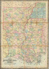
Rare separately issued map depicting Sherman's Campaign in Georgia.
The map shows most of Georgia and South Carolina. Includes defenses along the sea coast and around the principal towns (Atlanta, Chattanooga, Dalton, Marietta, Charleston, Savannah, Confederate prisons at Andersonville and south of Millen, Georgia., roads, railroads, towns, and other fine details.
What is perhaps most fascinating about the map is its intended purpose, as noted in excerpt below, the publisher intended that the map would be used by soldiers to report back to their family members as to their location and movements. The note at the top left states:
The horizontal and upright lines [of the map grid] represent five miles square. By referring [sic] to the number on the left and to the letter on the base, any point may be found to show the locality of the Union armies.
By this method those in the Army are enabled to inform their friends of the movements of their companies and their location and will also serve as a journal to each soldier.
The present example is state 2 of the map, with Bufford's imprint below the map and the city of Darien, Georgia removed from the area bealoe the neatline in the lower marginl.
The map is quite rare on the market. With the exception of this example, purchased at auction in early 2015, we note no examples on the market at auction or in dealer catalogues.
![[Florida Panhandle to Yucatan] Pas-Kaart Van de Golff van Mexico . . .](https://storage.googleapis.com/raremaps/img/small/93130.jpg)

![[First Map of the Mississippi River] Carte de la decouverte faite l'an dans l'Amerique Septentrionale](https://storage.googleapis.com/raremaps/img/small/93571.jpg)