![[Separately Published Example!] Map of the United States of America. Designed to illustrate the Geological Memoir of Wm. Maclure Esq. By John Melish / Charles Alexandre Lesueur](https://storage.googleapis.com/raremaps/img/small/90048.jpg)


|
||

|

|
|

|
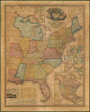
The Melish-Maclure map of the United States was one of the first geological map of the United States published in America.
The map appeared in the Transaction of the American Philosophical Society, to accompany William Maclure's Observations on the Geology of the United States. The map is the one of the first geological maps of the United States. Brightly colored to indicate the location of Primitive Rocks, Transition Rocks, Secondary Rocks, Alluvial Rocks, and Old Red Sand Stone, based on the Wernerian classification system. Also keyed to the legend is a "line to the westward of which has been found the greatest part of the Salt & Gypsum."
The map is one of the earliest maps to show the newly formed Alabama Territory and identifies a massive Missouri Territory, west of the Mississippi River. Indiana is directly below Lake Michigan, with Illinois Territory pushed far to the West off Lake Michigan and Chicago shown in Indiana.
Nice Indian detail throughout the newly formed Northwestern Territories and in Mississippi, Alabama and Georgia.
William Maclure is known as the "father of American geology." He published the first widely available geologic map of the United States in 1809. The first edition was based on Lewis' map, whereas this second edition used the Melish map as a base and it was published by Melish.
The map is quite scarce on the market, this being the third example we have handled in 20 years.
John Melish (1771-1822) was the most prominent American mapmaker of his generation, even though his cartographic career lasted only a decade. Melish was born in Scotland; he moved to the West Indies in 1798 and then to the United States in 1806. By 1811, he had settled in Philadelphia and published Travels through the United States of America, in the years 1806 & 1807, and 1809, 1810, & 1811, which was richly illustrated with maps.
Melish created several regional maps of the highest quality, as well as the Military & Topographical Atlas of the United States (Philadelphia, 1813, expanded 1815). The latter work is widely considered to be the finest cartographic publication to come out of the War of 1812.
By far his best-known work is his monumental map of the United States of 1816, Map of the United States with the contiguous British and Spanish Possessions. He began working on the map in 1815 and sent it to Thomas Jefferson for comment in 1816. Jefferson enthusiastically reviewed the map and returned it with his edits. Jefferson later hung an example of the map in the Entrance Hall of Monticello and sent it to associates in Europe.
Melish’s finished product was the first map of the United States to extend to the Pacific Ocean. After its publication in 1816, Melish ensured the map was as up-to-date as possible; it was reissued in 25 known states published between 1816 and 1823. The map captured the then rapidly changing geography of the United States, as well as various boundary disputes, treaties, and expansion.