


|
||

|

|
|

|
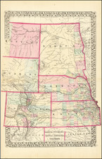
Rare separately issued pocket map of Kansas, Nebraska and surrounding regions by J.G. Wells, published by Morse & Gaston in New York.
The map extends west to the Rocky Mountains, two years before the Colorado Gold Rush. Kansas Territory extends to the Rocky Mountains with only a few western Counties, including a massive Arapahoe County, which would later become a Colorado County. Nebraska Territory extends to the Rocky Mountains and the Canadian Border, with just a few eastern counties shown.
To the south of Kansas, Indian Territory and the Northern part of Texas appear, including an early appearance of Dallas and Fort Worth.
In the North, a massive Minnesota Territory is shown, with a large section labeled "Proposed Territory of Dakota."
The map shows many Western Indian Tribes and forts. In the North the route of Lewis & Clark is shown. along the North Fork of the Platte River, the Great Emigrant Route to Oregon and California is named, with two different forks in the west. The Central Rail Route to the Pacific is also shown, along with a number of other unnamed major trails to the west.
Wells map is very rare on the market. We find no auction records or dealer records for the map in AMPR or Rare Book Hub. A fine addition for any antique map collector of Kansas and Nebraska.
![Carte De La Louisiane Et Du Cours Du Mississipi . . . Juin 1718 [1st State!]](https://storage.googleapis.com/raremaps/img/small/59797.jpg)

![[ Used by '49ers To Travel To California ] Map of Oregon and Upper California from the surveys of John Charles Fremont and others authorities drawn by Charles Preuss 1848](https://storage.googleapis.com/raremaps/img/small/100557.jpg)