|
||

|

|
|

|
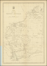
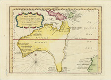
Remarkable large format working sea chart of Australia and New Zealand, published by James Imray.
The present map was used on a voyage to Australia by the American Clipper Ship Boston Light. Annotations include a line leaving Port Jackson and noting " Boston Light for Hong Kong August 1855" at the upper left.
The Daily Alta California of April 28, 1855 and May 1, 1855 advertised that the Boston Light, commanded by William Collagan, "Having one-half of her cargo positively engaged," will sail as above (For Melbourne or Sydney) on or before May 10, 1855. The ship sailed from San Francisco to Sydney, arriving July 20, 1855. The Sydney Morning Herald of August 20, 1855 and August 21, 1855 noted the Boston Light departing for Hong Kong in its list of Projected Departures. The inset also shows evidence of being used for navigation through the Bass Strait.
This fine chart, including inset plans of Bass Straits and Port Philip, is one of the largest sea format sea charts of the whole of Australia to have been published for commercial use at sea.
OCLC locates only a single example of this map (British Library). We locate on line the example of the Royal Museums Greenwich, but no example in any Australian institutional collection was noted.
James Imray was a publisher specialized in nautical charts. He started one of the most successful blue-back chart-selling companies of the nineteenth century; it is still in business today. Imray’s father was a dyer and he was born in Spitalfields, London, an area known for its garment industry. James did not want to enter the garment trade, however, and instead apprenticed to Stationer William Lukyn in 1818. Imray began his business as a book publisher and seller; however, he shared premises with Robert Blachford, a chartseller. Imray entered into business with Robert’s successor, Michael. He turned the business into a success and bought Blachford out in 1846, publishing under the imprint of James Imray. In 1854, son James Frederick joined as a partner and the imprint changed to Imray & Son. They thrived thanks to targeted marketing and excellent compilation charts that focused on trade routes. The busines entered in a long decline after the death of James Sr. in 1870. In 1899, Imray & Son amalgamated with Norie & Wilson. This conglomerate was bought by the Laurie firm in 1904 and today the business trades as Imray, Laurie, Norie & Wilson.