


|
||

|

|
|

|
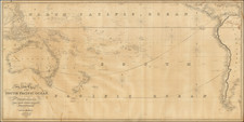
30 miles up the river into the interior, and contributed to the destruction of two batteries mounting 5 guns each. He was also present in all the operations up the Yang-tse-Kiang, where he led the Commander-in-Chief's ship to Nankin.
As a further reward for his service, Kellett was advanced to Post rank on December 23, 1842, and nominated, the next day, a C.B. He obtained leave to return to England in August, 1843; but in February, 1845, returned to sea as Captain of the Herald, engaged in surveying in the Pacific. Kellett left England June 26th, 1845, and after examining different parts in Chili and Peru, he commenced the survey of the coast of Columbia, between Guayaquil and Panama, till then only known from the accounts of Dampier and other older authors. This survey was completed with the aid of Commander James Wood, R.N. During the progress of the work the Herald made three voyages to the Arctic regions through Behring Strait, in aid of the expedition in search of Franklin, the first in 1848.
Returning to England in the Herald, in 1851, Kellett was appointed to command the Resolute in 1852, and during the two years following the north face of the Parry group was completed. In the spring of 1853 the Resolute was abandoned and her officers and crew returned to England in the Phoenix.
A court-martial held upon the officers and crew of the Resolute, at Chatham, for the loss of that ship, fully acquitted Captain Kellett and his officers, returning to him his sword.
In 1854, he was appointed Commodore of Port Royal, Jamaica, in the West Indies, and on vacating that post, received from the merchants of Jamaica a handsome service of plate in recognition of their estimation of his character.
From 1864 to 1867 he was Admiral Superintendent of Malta Dockyard, and his final appointment afloat was that of Commander-in-Chief of the China Station, whence he returned to England in 1872 much debilitated in constitution from the effects of. the climate.
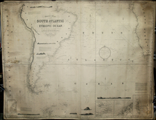
The chart is very rare on the market. OCLC locates only the example in the British Library.
The British Admiralty has produced nautical charts since 1795 under the auspices of the United Kingdom Hydrographic Office (HO). Its main task was to provide the Royal Navy with navigational products and service, but since 1821 it has also sold charts to the public.
In 1795, King George III appointed Alexander Dalrymple, a pedantic geographer, to consolidate, catalogue, and improve the Royal Navy’s charts. He produced the first chart as the Hydrographer to the Admiralty in 1802. Dalrymple, known for his sticky personality, served until his death in 1808, when he was succeeded by Captain Thomas Hurd. The HO has been run by naval officers ever since.
Hurd professionalized the office and increased its efficiency. He was succeeded by the Arctic explorer Captain William Parry in 1823. By 1825, the HO was offering over seven hundred charts and views for sale. Under Parry, the HO also began to participate in exploratory expeditions. The first was a joint French-Spanish-British trip to the South Atlantic, a voyage organized in part by the Royal Society of London.
In 1829, Rear-Admiral Sir Francis Beaufort was appointed Hydrographer Royal. Under his management, the HO introduced the wind force scale named for him, as well as began issuing official tide tables (1833). It was under Beaufort that HMS Beagle completed several surveying missions, including its most famous voyage commanded by Captain FitzRoy with Charles Darwin onboard. When Beaufort retired in 1855, the HO had nearly two thousand charts in its catalog.
Later in the nineteenth century, the HO supported the Challenger expedition, which is credited with helping to found the discipline of oceanography. The HO participated in the International Meridian Conference which decided on the Greenwich Meridian as the Prime Meridian. Regulation and standardization of oceanic and navigational measures continued into the twentieth century, with the HO participating at the first International Hydrographic Organization meeting in 1921.
During World War II, the HO chart making facility moved to Taunton, the first purpose-built building it ever inhabited. In 1953, the first purpose-built survey ship went to sea, the HMS Vidal. Today, there is an entire class of survey vessels that make up the Royal Navy’s Hydrographic Squadron. The HO began to computerize their charts in the late 1960s and early 1970s. In 1968, the compilation staff also came to Taunton, and the HO continues to work from there today.
![Oceani Occidentalis Seu Terrae Novae Tabula [The Admiral's Map]](https://storage.googleapis.com/raremaps/img/small/102935.jpg)