


|
||

|

|
|

|
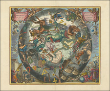
First State of the Rare Henri de Leth map of the Southern Hemisphere
This first state of De Leth's fascinating map captures the entire Southern Hemisphere from a polar projection. The cartography features many of the contemporary myths and anomalies associated with the Antipodes. The map features excellent projections of Australia and New Zealand, along with a number of early routes of exploration from the 16th, 17th and 18th centuries, including Tasman, Halley, Damiper, Magellan, Le Maire, Mendana and others.
The first state of the map predates the following additions and changes, which appear only on the later states:
- Bouvet route, and marginal map and information
- The "port", allegedly discovered by Sir Francis Drake, otherwise known as Drake's Island, in 1577, which lies to the southwest of Cape Horn.
- The discoveries of Captain Davis and Captain Sharp to the west of the Straits of Magellan
- The annotations regarding Amerigo Vespucci's voyage to the Southern Hemisphere
- Different text in the lower corners and far fewer place names along the Chilean coast of South America
- Notes the islands discovered by Roggeveen in 1722
- More detail in New Zealand
Some of the more notable features are Carpentaria attached to New Guinea; Tasman's route, along with a depiction of Tasmania as per Tasman, distinctly separate from Australia.
This first state is apparently quite rare on the market. We date the map based upon the date given by the Australian National Library.
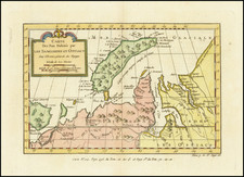
![(Strait of Magellan) Freti Magellanici ac novi Freti vulgo Le Maire exactissima delineatio. [The most exact delineation of the Strait of Magellan and the new Strait, commonly known as Le Maire.]](https://storage.googleapis.com/raremaps/img/small/99612.jpg)
![Tabula Geographica Hemisphaerii Borealis ad emenatiora quae adhuc prodieruntexampla jusqu Acad. Reg. Scient. et Eleg. Litt. Boruss. descripta [with:] Tabula Geographica Hemisphaerii Australis...](https://storage.googleapis.com/raremaps/img/small/102686.jpg)