
![[Alabama and Mississippi] Chart of the Sources of the Mobile and of the River Yazoo Including a part of the Course of the Mississipi From the River Margot to the Natches. By Georges Henri Victor Collot](https://storage.googleapis.com/raremaps/img/small/78960.jpg)


|
||

|

|
|

|
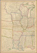
Detailed map of a portion of Mississippi, Mobile and Yazoo Rivers, extending from just south of Memphis, Tennessee to just north of Mobile Bay, from the explorations of General Georges Collot.
Collot's map of the the Sources of the Mobile and Yazoo Rivers was compiled from his observations during his clandestine reconnaissance of the West on behalf of the French Government in 1796.
Rumsey describes the map as "A wonderful map and one of the first maps to show specifically the area of Mississippi and Alabama." It is in fact the first large-scale depiction of the Deep South and an extraordinary record of the region shortly before the beginning of American settlement. The map includes virtually all of the present State of Mississippi and all of Alabama north and west of the Alabama and Coosa rivers.
Acting under instructions from Citizen Adet, French Minister to the United States, General George Henri Victor Collot undertook a secret reconnaissance in 1796 of what was then the western American frontier. Collot traveled from Pittsburgh down the Ohio to the Mississippi, up the Mississippi to the Missouri and Illinois Rivers, and then back down the Mississippi to New Orleans. During his journey, he constructed a large number of exceptionally fine manuscript maps and views of the region that he traversed. Many of these were groundbreaking, containing never before recorded information about a wilderness that was just beginning to undergo settlement.
Collot's maps were engraved in Paris in 1804, but publication was suppressed due to Napoleon's sale of Louisiana to the United States the previous year. The sale ended any possibility that the region could be acquired by France. As a result, the plates were not printed until 1826, when they were issued in a limited number as Voyage dans l'Amerique Septentrionale.
A nineteenth-century bookseller called this work "one of the most famous, most important, and rarest of all books of Mid-Western Explorations." Eberstadt pronounced it "extraordianrily rare." Its rarity is due to the deliberate destruction of all but three hundred French and one hundred English copies by the publisher, who had purchased the edition from Collot's estate, hoping to increase its value.
This map is without doubt one of the most interesting of all the Collot maps. With the exception of the Pearl, the river system is well-understood, if a bit distorted. Very little settlement has taken place, except for the Spanish establishments at Natchez and Nogales (Vicksburg) on the east bank of the Mississippi, and northwest Alabama is labelled "Country Quite Uninhabited." There are a few scattered establishments in northwest Mississippi, along the upper Tombigbee (Gollaters, Johnson, and Colbert), as well as several Native American villages ("Great Village of the Chickasaws," "Half-Breed Settlement," etc.). An old French Settlement" is identified on the south bank of the Tennessee near the present town of Florence, Alabama.
Established by the French in 1716, Natchez was one of the most important settlements in the lower Mississippi Valley. The town had been occupied by the Spanish in 1763, who were still in control when Collet visited in 1796. The town and nearby Fort Rosalie are shown in some detail. Fort Nogales, founded by the Spanish in 1791, was known as "the Gibralter of Louisiana." It was located approximately one mile north of the present city of Vickburg, at a spot still known as Fort Hill. The fort was evacuated in 1798, when the Spanish turned over the east bank of the river to the United States.
In 1763, the territory west of the Mississippi River was ceded to Spain by France, while the lands east of the river were ceded to Britain. In 1783, the lands east of the Mississippi formally became territory of the United States, although American possession of the region was tenuous at best. The mainly Francophone inhabitants of the Mississippi Valley had little affinity for Anglo-American rule, and their frontier lifestyle made them virtually impossible to control.
It was in this context that the government of post-Revolutionary France, the 'Directoire', schemed to reacquire France's lost American territories. The Dircetoire had an acrimonious relationship with both America and Spain, and the possibility of supporting an insurrection by the region's Francophone inhabitants was considered by many to be a viable means for France to regain Louisiana and the Illinois Country.
In 1796, the Directoire charged General George Henri Victor Collot (1750-1805) with undertaking a reconnaissance mission to the Mississippi frontier, in order to assess whether the region could be retaken by France. Collot seemed like the perfect man for such an assignment. A former governor of Guadeloupe, he was an accomplished veteran of colonial service and an extraordinarily gifted mapmaker.
While Collot's intellectual achievements were impressive, his mission was a political disaster. Collot was arrested at Fort Massac on the Ohio River by the American officer Zebulon Pike (himself soon to become a legendary explorer). Pike told Collot that "you have been indefatigable in surveying the Ohio, by taking the courses, distances, heights, etc., as well as reconnoitering the adjacent area for which you exhibit no authority". While he was well aware that Collot was a French agent-provocateur, the officious Pike set him free, as he could not find any legal means of detaining him. Collot was, however, later shadowed by Spanish agents and arrested and deported as soon as he arrived in New Orleans. Fortunately, the Spanish governor allowed Collot to retain his maps and papers.
Louisiana and the lands west of the Mississippi were returned to France by Spain in 1800, and Collot hoped that this would only increase interest in his work, however this was not to be. Unfortunately for Collot, in 1803, the new French dictator, Napoleon Bonaparte, decided to sell Lousiana to America, bringing a practical end to Collot's work on behalf of the French Government.
The map is very rare, as is the book in which it was published. It has been noted that "A nineteenth-century bookseller called this work 'one of the most famous, most important, and rarest of all books of Mid-Western Explorations.' "
An essential map for regional collectors.
Georges Henri Victor Collot (1750-1805) was a French soldier, explorer, colonial official, and spy. He served in France’s possessions in North America and the Caribbean. Born in Chalons-sur-Marne in northeastern France in 1750, the young Georges joined the army. He quickly ascended the ranks.
Collot’s first American experience was as a French officer fighting alongside General George Washington in the Revolutionary War. He served as aide-de-camp and maréchal des logis under French general Rochambeau.
From 1792-4, now a Major General, Collot was Governor of Guadeloupe. His time in the Caribbean was short-lived, however, as the British invaded the French colony, imprisoned Collot, and sent him to New York. He evaded punishment and the French turned his presence to their advantage.
Collot was ordered on a reconnaissance mission on the Ohio and Mississippi Rivers. He was to assess the military capacity and fortifications of their imperial rivals, Spain and Britain, as well as to report on the expansion of the Americans westward.
In the spring of 1796, Collot set out. He navigated southward through Illinois and Upper and Lower Louisiana, drawing detailed maps and plans along the way. His presence was not a secret, however; the English, Americans, and Spanish all issued orders to halt his progress. Collot was arrested at Fort Massac on the Ohio River by the American officer Zebulon Pike, but released when Pike found no legal basis for holding him. After reaching the Mississippi, Collot turned upriver to St. Louis, and explored short distances up the Illinois and Missouri rivers as well. While in St. Louis, he may have had access to the maps of the known course of the Missouri River, of Pierre Antoine Soulard, whose maps would later be utilized by Lewis & Clark, as well as access to information from Jean Baptiste Truteau, whose expedition up the Missouri River had just been completed in June 1796.
When Collot arrived in New Orleans in October of 1796, the Spanish Governor, Carondelet, seized Collot and his maps. He was released in early December and returned to France.
Changing imperial politics delayed the publication of Collot’s account of his voyage until 1805. He died in the same year. At the time of his death, his spy mission was little known. It was only in 1826 that a limited reissue of his account was published by Arthus Bertrand. He printed 300 French copies and 100 English; Bertrand destroyed the surviving 1805 examples.
Collot’s maps and plans are superbly rendered cartographic works detailing the contested Mississippi and Ohio River Valleys and they remain very scarce today.


![[ New Orleans, Louisiana / Southern Travel Letter ] Lyman Adams letter to Austin Adams, December 21, 1839](https://storage.googleapis.com/raremaps/img/small/96629.jpg)