|
||

|

|
|

|
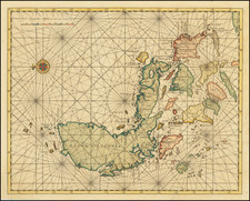
Finely executed working blue backed sea chart of the Indian Ocean and the Southwestern Pacific Ocean, published by R. Blachford & Company in London, first issued January 1, 1830.
The chart provides remarkable detail throughout, including manuscript annotations tracking voyages around the Cape of Good Hope and across the Indian Ocean toward the Bay of Bengal Singapore and to the South side of Australia and Tasmania, on to Sidney.
The Australian Coastline is still not completely and accurately mapped. A number of important ship tracks are located.
Includes inset plans of Port Jackson, Torres Strait Mauritius, Port Louis and Bourbon, and profile views of the Cape of Good Hope, Isle of France and Island of Rodrigues.
The map was re-issued in 1835, with the current revised title.
OCLC locates only a single example (1835 edition at the National Library of Australia). We note also a copy of the 1848 edition on their on-line catalog.
Blachford was an Irish chartmaker best known for publishing blueback nautical charts. His introduction to the chart trade was likely through his father-in-law; in 1802, Blachford married Elizabeth Moore, the daughter of John Hamilton Moore, who was a renowned publisher of nautical texts and charts. Blachford only worked with Moore for two years. By 1805, he had set up his own shop in the Minories. Many of his charts from this time were derived from the Moore’s work and re-engraved by Samuel Stockley. Business was slow, however, and Blachford filed for bankruptcy in 1819. To counter this bad luck, he partnered with William Lane until 1821, working out of an address in Leadenhall. He then moved back to a Minories address and this shop would be his base of operations for over a decade. His new partner was William Blachford, possibly a relative. Their charts focused on British coastal navigation. Robert and William retired around 1835; they passed the business to Michael Blachford. Michael, in turn, partnered with James Imray and their business was successful. Imray bought Blachford out in 1846, continuing to grow his business into one of the most successful of the nineteenth century.
![[ With Unusual Annotations in Red ] A Draught of the South Part of Africa from Cape Bona Esperance to Delagoa](https://storage.googleapis.com/raremaps/img/small/99414.jpg)
![[Napoleon in Exile] A Descriptive Sketch of The Island of St. Helena, Including Its Extent, Climate, Productions, Population, Government, Means of Defense, &c. &c.](https://storage.googleapis.com/raremaps/img/small/50902.jpg)