


|
||

|

|
|

|
The First Official Postal Map of the United States
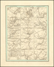
Fine example of Abraham Bradley's postal map of the United States. One of the most important 18th century maps of the United States, and a landmark in both the history of cartography and American Postal history.
Bradley's map is not only the first postal map of the United States, it includes the first printed postal route time table published in the United States, and is without question a seminal artifact in American postal history.
Abraham Bradley was a Litchfield, Connecticut, lawyer, who had an extraordinary career as a senior civil servant in the U.S. Post Office Department. Bradley joined the Postal Department in 1792, was promoted to First Assistant Postmaster General in 1800, and served until being removed from office in the Jacksonian purges of 1829.
It is hard to overstate the importance of the Postal Department in the first decades after the revolution. The founders saw effective postal service as a precondition for an informed citizenry and vibrant democracy, and Postmaster General was one of the first Cabinet positions created by Washington. At times during Bradley's tenure, The Postal Department accounted for more than 75% of the Federal bureaucracy. By his retirement, Bradley oversaw more than 8000 local offices and 110,000 miles of post roads. During these years, Bradley essentially acted as the Department's Chief Operating Officer, overseeing among other things route selection, contracting, finances and even responding to complaints about lost or stolen mail. In light of his position, Bradley was arguably the American most motivated to produce a viable postal map, and certainly the best informed.
First issued in 1796 (northeast sheet only), Bradley's postal map is among the most important maps in American history. Bradley's map is one of only 4 large format maps of the United States to have been published in America prior to 1800, two of which (maps by Abel Buell and John Norman) are unlikely to ever again appear on the market. The map provides an exceptionally detailed look at the post offices and postal routes of America, as they existed at the end of the 18th Century, locating every post office then in operation. The map also includes the first printing of the first American postal delivery time and route schedule (which may have also been issued separately, although there are no known separately printed examples which have survived).
In 1796, when Bradley published his first Map of the United States, Exhibiting the Post-Roads, the Situations, Connections, and Distances of the Post-Offices, less than 15 years after the end of the War of Independence, most citizens of the fledgling United States still had no real conception of the magnitude of their young nation. Bradley's postal map, with its schedule chart, was a perfect combination of Bradley's skills and obsession for precision scheduling. This unique U.S. map was on public display in almost every large post office in the country, and provided citizens with an impressive visual depiction of the scope of the United States at a time when the search for a national culture and national identity was at its height, after the final and official separation from Great Britain. The inclusion of stagecoach schedules promoted, encouraged and broadened popular notions of the concept of time beyond seasonal and religious practices.
The map was advertised for sale on October 3, 1796 as follows:
The above map may be had of the author at the General Post-Office…..Prices from 3 ½ to 5 dollars each, according to the manner in which they are finished. The progress (or arrivals and departures) of the Mail on the Main Line may be had separate for 37 ½ cents
For many colonial residents, the Bradley's map was the iconic symbol of a unified United States. Citizens began to consider (and later demand adherence to) weekly and daily notations of time, as measured by the institution of regularly-scheduled mail service.
The map's true value is its exceptionally detailed depiction of the post offices and post routes of the young United States at the end of the 18th century. Buehler and Caldwell note:
What makes the map extraordinary is its depiction of the American postal system in a single coherent image. It shows every one of the roughly 450 existing post offices and every postal route, with distinctive symbols differentiating "post roads," "post roads established by contract," and "post and stage roads." Each route is marked to indicate the mileage between post offices. The varying density of the network displayed on the map serves as a profile of national expansion and development. ("Mapping a Networked Nation," p. 10)
A fascinating historical footnote for Bradley's map was its use by Louis Philippe, Duc d'Orléans, future King of France (1830-1848), during his travels in America. Louis Philippe spent more than three years in American exile, from 1796 to 1800. At the beginning of his exile in 1796, he and his two brothers visited an aging George Washington at Mount Vernon, where they revealed their desire to explore the mysterious interior of America. Washington presented them with a copy of Bradley's map and outlined a route for the brothers in read. The map became a favorite keepsake for Louis Philippe, who years later, as King of France, would proudly produce the map for visitors and share the story of how Washington had redlined the map in his own hand for a young Louis Philippe and his brothers.
The first edition of the map is known in 4 states, which can be identified as follows:
- State 1: Northeast Sheet only
- State 2: 4 sheets, including the Time Table
- State 3: Georgia named, but appearing on 2 lines (GEOR/GIA). Copyright date of September 26, 1796, appears in top left corner.
- State 4: Note in Georgia: "All West of this line is claimed both by the United States and by Georgia). A symbol for discountinued post roads is shown in the ocean, off the coast of South Carolina.
The 4 sheets which comprise the Bradley were produced using 3 different sheet engravers:
- William Barker (time table),
- William Harrison (Southern and Western Map Sheets)
- Smither (Northeastern map sheet).
The present map is the fourth state of the 1796 edition. Caldwell & Buehler offer a date of 1800 for the map, based upon the inclusion of post offices which were not opened until 1800. Other significant additions include:
- New Post Road From Wilmington NC. to Charleston SC.
- New Post Road From Woodbury NJ to Little Egg Harbor NJ.
- New Post Road From Farquuier Co., VA to Culpepper Co. VA.
- Second Post Road Running Southeastward out of Grrensburg PA through the new post office at Somerset PA.
- New Post Road from Lewisburg PA to Huntington PA
- New Post Road through Mifflin County to Huntington, PA
- New Post Road from Old Ft. Schuyler, OH to Cincinnatus (Cincinnati)
- New Post Road from Oxford Academy to Cincinnatus (Cincinnati)
- New Post Road from Boston to Walpole and Charleston NH
- New Post Road from Portland, ME to Sandwich, NH
- New Post Road from Worcester MA to Warwick, MA
- New Post Road from Bedford NY to Bennington VT
18th Century states of the map (of which there were 4) are of the utmost rarity. The last auction record for an 18th Century edition of the map was in 1976. The Caldwell & Buehler articles notes only one known examples of the first edition of the map:
- State 1: Library of Congress (Northeast sheet only)
- State 2: 4 known examples (American Geographical Society, American Philosophical Society, Library of Congress and New York Public Library. Harvard has 3 of 4 sheets, lacking the timetable. The AGS and Library of Congress copies were almost certainly joined later, based upon visual observations. The NYPL copy, based upon a visual inspection of the on-line illustration, is almost certainly a later state of the map, as the timetable is clearly state 2 (see below).
- State 3: 8 known examples (Boston Public Library, British Library, Library of Congress, Massachusetts Historical Society, New York Public Library, Osher Map Library, and University of Michigan, and MacLean Collection)
- State 4: 6 known examples (Hagley Museum & Library, John Carter, Brown, Library of Congress, National Postal Museum, Yale, MacLean Collection).
There are two states of the timetable. The first state was likely intended to be offered separately. The second state of time table (first issued with the second complete state of the map) was amended to harmonize the bottom and left neat lines with the adjoining sheets, to make it look more like a wall map: (a) lower and right inner neat lines have been added in the second state (with these lines running awkwardly through existing text in the timetable); and (b) another uneven cut to fit the left side of the time table together with the map sheet to the left has been made, to harmonize the lines that make up longitude and latitude.
An enlarged second edition was published in 1804 (4 known states) and a third edition in 1825 (1 known state).
There are no known examples of the map in any institutional collection west of the Mississippi River.
Rarity
The map is very rare on the market. We know of only a single copy of the first edition offered for sale in the past 25 years (the example sold by our firm to a private collector). The last example at auction was at Sothebys in 1991.
Abraham Bradley was born in Litchfield, Connecticut. He is an important figure not only in early American cartography, but in early American history as well. Initially, Bradley trained as a lawyer and moved to the Wyoming Valley of Pennsylvania to practice. There he met Judge Thomas Pickering, who took Bradley with him to Philadelphia when he was appointed Postmaster General by George Washington in 1791.
As Pickering's clerk, Bradley created postal maps which showed the budding system of post offices and routes. A self-taught mapmaker, Bradley quickly gained considerable skill and became well-known for this carefully drawn maps. His most famous map is the postal route map of 1796, which shows the young United States and includes an innovative table that calculated the time it would take a letter to travel around the country.
In 1799, Bradley was appointed Assistant Postmaster General, a position he would hold until 1829. As part of his duties, Bradley supervised the moving of the General Post Office Department from Philadelphia to Washington DC. In 1804, with the help of British mapmaker Aaron Arrowsmith, Bradley updated his postal map, which featured in practically every post office in the states and territories. Bradley would continue to create route maps, and to update his most famous map, throughout his career, including in 1810 and 1825.
During the burning of Washington DC in the War of 1812, Bradley housed the records and archives of the General Post Office Department in his Maryland farmhouse. His service with the Post Office came to an abrupt end, however, with the election of Andrew Jackson. Although he had served under five Postmasters General, Jackson dismissed Bradley for partisan reasons. Bradley then served as secretary to the Franklin Insurance Company. He died at his farmhouse in 1838, leaving behind eight children. He is remembered for his careful custodianship of the nascent Post Office, and for creating maps that made Americans feel connected to their fellow citizens.

![[ New England and Great Britain ] Nova Anglia Gaudenbonis Plurimis De Est Tame Adhuc Angelorum Regin [and] M[ag]na Britannia Dei Matri Cuitu & Beneficiis olim hodieque celebrata](https://storage.googleapis.com/raremaps/img/small/95667.jpg)
![[HAPAG Map of the United States and Canada]](https://storage.googleapis.com/raremaps/img/small/78779.jpg)
![[North Carolina]. Carte Geographique, Statistique Et Historique De La Caroline Du Nord](https://storage.googleapis.com/raremaps/img/small/57603.jpg)