|
||

|

|
|

|
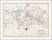
Fine Original Color Example of De Jode's Rare Cordiform Map of the World
Exceptional old color example of De Jode's scarce heart-shaped projection, etched by the van Doetecums and first published as a separately issued map in 1571.
The central projection is surrounded by ten wind heads, cherubic faces blowing currents across the globe. In the lower left is a celestial sphere, while a terrestrial sphere, focused on the Atlantic and Africa, sits in the lower right corner. The etchers names, Joannes and Lucas Van Doetecum, are in the top left, near a wind head in the corner.
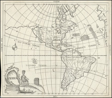
The map provides a fine depiction of the newly separate North America, no longer shown attached to Asia. Japan, or Giapan as it is included here, is closely sandwiched between California and Asia. There is little speculation as to the far north of North America.
South America is well-shaped, with its southernmost point separated from a large unknown continent by the Straits of Magellan. Tierra del Fuego is but one peninsula in the vast landmass to the south which, thanks to the cordiform projection, seems to hug half the world. The Pacific Ocean is peppered with early Spanish discoveries, while the East Indies includes the main islands already contacted for spice trade.
All the continents, save the unknown Southern Continent, are covered in settlements that are marked with small buildings symbols and colored red. Interestingly, Europe contains the fewest settlements. For example, London is not marked and nor is Antwerp, where this map was made.
The southern continent is not entirely devoid of labels, however. They include Psitacorum regia, or region of the parrots. Psitacorum regio appeared on Mercator's 1541 globe and his 1569 world map in approximately the position De Jode has it. It was supposed to have been sighted by Portuguese sailors, or Lusitanians as it says on the Mercator and de Jode maps.
Origins and States
In addition to Mercator as a source, and as mentioned in the title in the first state of the map, De Jode's cordiform world map is a reduced version of Abraham Ortelius's eight sheet world map of 1564, which was survives in only three known examples. It is believed that Ortelius in turn had followed a now lost eight sheet cordiform world map of Giacomo Gastaldi, published circa 1561.
This third state (see states below) appeared in De Jode's atlas entitled, Speculum orbis terrae (Antwerp: 1578). Gerard De Jode (1509-1591) released his atlas in a golden age of Dutch atlas production: the first atlas was released in 1570, also in Antwerp, the first town atlas in 1572, the first pocket atlas in 1577, the first regional atlas in 1579, the first nautical atlas in 1584, and the first historical atlas in 1595. The first atlas was Ortelius' Theatrum orbis terrarium, and De Jode's was intended as competition for Ortelius'. Gerard Mercator was also preparing an atlas at the time, and corresponded with Ortelius, but it would not appear in full until 1595, a year after Mercator's death.
Although the Speculum was ready as early as 1573, it was not published until 1578. This is most likely due to Oretlius' influence and his privilege over atlas publishing, which expired just before De Jode finally published. The atlas was the result of collaboration between De Jode, the geographer Jan van Schille of Antwerp, German physician Daniel Cellarius, and the etchers Joannes and Lucas van Doetecum.
Although never as successful as Oretlius' Theatrum, the Speculum did get republished in a second edition in 1593, two years after De Jode's death, by Arnold Coninx. After his death, Gerard's son, Cornelis (1568-1600), and his wife, Paschina, ran the shop. Unfortunately, Cornelis died young in 1600, aged only 32, and the stock and plates were sold to the publisher Joan Baptista Vrients. Vrients had also recently purchased the plates for Theatrum, giving him a monopoly over Antwerp atlas publication. Vrients acquired the De Jode atlas plates only to suppress them in favor of the Ortelius plates, thus the De Jode atlas maps are quite rare on the market today.
Shirley notes five states of the map, although it is not clear the dates or order of states 2, 4, and 5:
- First state, known in three examples, which has a different title ( Nova Totius Terrarum Orbis Descriptio)
- Second state, with a new title ( Universi Orbis Seu Terreni Globi In Plano Effigies), but lacking the privilege (and likely pre-dating the publication of De Jode's atlas)
- Third state, including the words " cum privilegio" in the title and used for the first edition of De Jode's Speculum
- Fourth state, with additional place names such as ocean names and " Tara Incognita" in North America
- Fifth state, van Doetecum names missing
The present example is an unusually fine, dark impression of the third state of the map. Old color examples of this map are extremely rare, especially in such fine condition.
Cornelis Koeman, Gunter Schilder, Marco van Egmond, and Peter van der Krogt, “Commercial Cartography and Map Production in the Low Countries, 1500-ca. 1672,” in History of Cartography, vol. 3, part 2 (Chicago: University of Chicago Press, 2007), 1296-1383.
Gerard De Jode (1509-1591) was a pre-eminent mapmaker in the late seventeenth century, a time when the Dutch dominated the map trade. He was known for his many maps, some of which featured in Speculum Orbis Terrae (first edition Antwerp: 1578). Although never as successful as Ortelius’ Theatrum, the Speculum did get republished in a second edition in 1593, two years after De Jode’s death, by Arnold Coninx, and included this map. After his death, Gerard’s son, Cornelis (1568-1600), and his wife, Paschina, ran the shop. Unfortunately, Cornelis died young in 1600, aged only 32, and the stock and plates were sold to the publisher Joan Baptista Vrients.