|
||

|

|
|

|
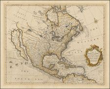
Scarce map of North America, published shortly after Texas declared its independence from Mexico. This map also includes significant revisions in British Columbia attributable to the explorations and discoveries made by the Northwest Company and Hudson's Bay Company in the region.
The map is remarkably detailed, especially in the West. Texas is now named for the first time on this map (the 1834 edition calls Texas "Santander"), with the "Free Indian" region in the north of Texas remaining on the map. Northwest of Texas, there is a significant amount of Indian and topographical details, more so than on most maps of the period. Oregan Territory includes the details from Lewis & Clark, the Astorians, and other early explorations in the region, along with lots of Indian details.
The map includes fine detail in Upper California, including the Missions, mythical rivers, notes on the Russian Settlements near San Francisco, and excellent detail north of the Gila River. Highly details NW Coast of America, including American, British and Russian settlements and forts, Indian Tribes, etc. Nice detail in Alaska, which is called "Polar Kreis." Massive Northwest and Missouri Territories shown.
One of the other significant revisions between the 1834 and 1837 editions of the map is the extension of the Rocky Mountains far to the North, ending just short of the MacKenzie River, with a great deal of additional topographical details concerning the mountains and rivers in this region. The map shows significant improvement on the southernmost parts of the MacKenzie River and now shows the Liards River as a tributary. The region between Sitka and the newly added mountain range includes significant topographical details to the North and East of Fort Babson.
The identification of Fort Liard is probably drawn from Simpson, but is curiously late to appear on the map. Fort Liard was established by 1807, but a falling-out with the traders occurred. In his report of May, 1821 to the Hudson Bay Company Governor and Committee, George Simpson notes that this post "was amongst the first established in the District, but abandoned several years ago in consequence of the people being massacred by the Indians to the number of sixteen or eighteen and not re-established until last year." With the amalgamation of the Hudson Bay Company and the Northwest Company in 1821, the post was taken over by The Bay and the fur trade era began in earnest.
The coastline of Alaska is also significantly improved along the northern coastline, providing final details to a region which was uncharted on the 1834 edition of the map.
Weiland's maps are quite scarce, this being the first example we have handled of this 1834 edition. One of the most detailed western maps of the period. Not in Wheat.


![Amerique Septentrionale divisee en Ses Principales parties . . . . 1692 [California as an Island]](https://storage.googleapis.com/raremaps/img/small/95812.jpg)