


|
||

|

|
|

|
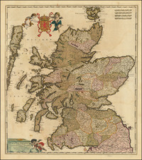
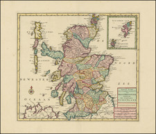
Striking large format map of Scotland, based upon the recent surveys of John Ainslie & c. . . . 1813.
John Ainslie ( 1745 - 1828) was a Scottish surveyor and cartographer, born in Jedburgh, the youngest son of John Ainslie, a druggist. He began his career as an apprentice to the "Geographer to King George III", engraver and publisher Thomas Jefferys, and worked as a surveyor and engraver for the English County series of maps.
After Jefferys' death he returned to Scotland where he surveyed Scottish counties, engraving and publishing the maps. His primary focus was on the coasts and islands of Scotland. The quality of his maps challenged others to improve their mapping style making maps more clear and easy to read. From 1787 to 1789 Ainslie worked on a new nine sheet map of Scotland, publishing it in 1789. The map was a landmark in the improvement of the outline of Scotland and for the first time showed the Great Glen as a straight line and Skye, Mull, and Islay shown with more accuracy than had previously been seen.
He worked as a surveyor on several civil engineering projects including the Forth and Clyde canal with Robert Whitworth, Charles Rennie on Saltcoats harbour, and the Glasgow to Ardrossan canal.
William Faden (1749-1836) was the most prominent London mapmaker and publisher of the late-eighteenth and early-nineteenth centuries. His father, William Mackfaden, was a printer who dropped the first part of his last name due to the Jacobite rising of 1745.
Apprenticed to an engraver in the Clothworkers' Company, he was made free of the Company in August of 1771. He entered into a partnership with the family of Thomas Jeffreys, a prolific and well-respected mapmaker who had recently died in 1771. This partnership lasted until 1776.
Also in 1776, Faden joined the Society of Civil Engineers, which later changed its name to the Smeatonian Society of Civil Engineers. The Smeatonians operated as an elite, yet practical, dining club and his membership led Faden to several engineering publications, including canal plans and plans of other new engineering projects.
Faden's star rose during the American Revolution, when he produced popular maps and atlases focused on the American colonies and the battles that raged within them. In 1783, just as the war ended, Faden inherited his father's estate, allowing him to fully control his business and expand it; in the same year he gained the title "Geographer in Ordinary to his Majesty."
Faden also commanded a large stock of British county maps, which made him attractive as a partner to the Ordnance Survey; he published the first Ordnance map in 1801, a map of Kent. The Admiralty also admired his work and acquired some of his plates which were re-issued as official naval charts.
Faden was renowned for his ingenuity as well as his business acumen. In 1796 he was awarded a gold medal by the Society of Arts. With his brother-in-law, the astronomer and painter John Russell, he created the first extant lunar globe.
After retiring in 1823 the lucrative business passed to James Wyld, a former apprentice. He died in Shepperton in 1826, leaving a large estate.
![[Pictish Man Holding Sword and Pike] Alterius viri Pictis vicini icon IIII](https://storage.googleapis.com/raremaps/img/small/99890.jpg)