


|
||

|

|
|

|
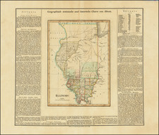
Rare late state of this early map of Wisconsin and Iowa from Greenleaf's scarce New Universal Atlas. One of the earliest obtainable maps to show Wisconsin (pre-dating its statehood) and Iowa.
This map stretches from the Great Lakes across the Plains with little detail outside of southern Wisconsin and Eastern Iowa where a few counties are separated by color. In southern Wisconsin travel routes, towns, and railroads are shown. Many rivers and streams are shown and named on the map.
In this late state (first issued in 1848), Crawford County and St. Croix County are shown in Wisconsin and the Carver Tract no longer appears. The Meuse River is added to the west of Pembina Lake. Also Itasca Lake and the Headwaters of the Missisisppi River are shown for the first time. Lake of the Woods is named for the first time and the Northern Boundary of the US and Canada is moved down from French Lake, Hunter's Lake, etc., to the line between Grand Portage and Crooked Lake, with a line shown for the first time.
Further South, in Iowa, Council Bluffs is added, as are the Pottawatomies lands and the Sacs & Foxes. The number of early Iowa counties to the west of the Mississippi River has more or less doubled and the lands of the Winnebagos has been added.
A very scarce map--the first time we have ever seen this late state.

![Carte Qui Contient La Maniere Dont Se Fait La Chasse Des Bouefs Sauvages . . . [Buffalo, Niagara Falls, Calumet Village, Huron & Illinois Indians]](https://storage.googleapis.com/raremaps/img/small/93146.jpg)