


|
||

|

|
|

|
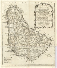
Finely engraved map of Barbados, drawn from the observations of the Reverend Griffin Hughes and published by Thomas Jefferys in London.
The map is colored by Parish and highlights the early towns, churches, forts, Sugar Works, Mills, Plantations, roads, rivers, mountains and other topographical features.
The Reverend Griffith Hughes (fl. 1707-1758), was a naturalist and author. He served as the rector of St. Lucy's Parish in Barbados from 1736 until his return to London. While on Barbados, he recorded his observations of the natural features, plants, and wildlife over a period of several years.
Thomas Jefferys (ca. 1719-1771) was a prolific map publisher, engraver, and cartographer based in London. His father was a cutler, but Jefferys was apprenticed to Emanuel Bowen, a prominent mapmaker and engraver. He was made free of the Merchant Taylors’ Company in 1744, although two earlier maps bearing his name have been identified.
Jefferys had several collaborators and partners throughout his career. His first atlas, The Small English Atlas, was published with Thomas Kitchin in 1748-9. Later, he worked with Robert Sayer on A General Topography of North America (1768); Sayer also published posthumous collections with Jefferys' contributions including The American Atlas, The North-American Pilot, and The West-India Atlas.
Jefferys was the Geographer to Frederick Prince of Wales and, from 1760, to King George III. Thanks especially to opportunities offered by the Seven Years' War, he is best known today for his maps of North America, and for his central place in the map trade—he not only sold maps commercially, but also imported the latest materials and had ties to several government bodies for whom he produced materials.
Upon his death in 1771, his workshop passed to his partner, William Faden, and his son, Thomas Jr. However, Jefferys had gone bankrupt in 1766 and some of his plates were bought by Robert Sayer (see above). Sayer, who had partnered in the past with Philip Overton (d. 1751), specialized in (re)publishing maps. In 1770, he partnered with John Bennett and many Jefferys maps were republished by the duo.
![Guadaloupe [with] Antigua [with] Mariegalante &c.](https://storage.googleapis.com/raremaps/img/small/72024.jpg)
![Carte Reduite des Isles Antilles Dressee au Depost des Cartes et Plans de la Marine… [Large Inset of Virgin Islands]](https://storage.googleapis.com/raremaps/img/small/68206.jpg)
![[Barbados] Carta De La Isla De La Barbada Reducida y Gravada Por D. Juan Lopez . . . 1780](https://storage.googleapis.com/raremaps/img/small/85048.jpg)
![[St. Barths / St. Martin / Anguilla / Antilles ] -- Plans of Ports Surveyed by Captain Edward Barnett R.N. 1846](https://storage.googleapis.com/raremaps/img/small/70950.jpg)