|
||

|

|
|

|
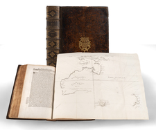
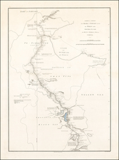
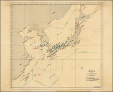
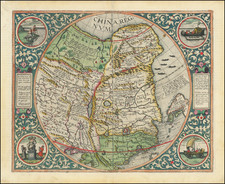
Important early sea chart of the China Sea, published by Jean Baptiste Nicholas D. D'Apre de Mannevillette. in Paris, for his Neptune Orientale.
The map extends from Fuzhou and Taiwan in the north, to the Philippines, Borneo and Bintam, in the south, and shows the whole of the coast of Southern China and Vietnam, including Macao and an unnamed Hong Kong.
The map includes a lettered key next to the title, which lists the vessels that had explored the region between 1752 and 1763. Of particular note on the map is the depiction of Hong Kong as "Fan-chin-cheo".
The map was first published by Dalrymple, in London 1771, and COPAC lists the British Library as having an example. This particular example is a slightly later edition (c.1775), published by D'Apres de Mannevillette in Paris, which appeared in later editions of Le Neptune Oriental.
Jean .B.N.D. D' Apres de Mannevillette (1707-1780), was a famous French sailor and hydrographer. During a voyage to China in 1728, he succeeded in correcting the latitudes of many places using new instruments. Back in France he devised a plan to correct and publish all the existing maps of the route to China: the Red Sea, the coasts of India, Malaya, the northern parts of Indonesia, Indochina and China. When the first edition of his Atlas Le Neptune Oriental (containing only 22 charts), was published in 1745, it was regarded as a major achievement and a library indispensable to navigators. In 1762, Mannevillette was appointed director of an office established by the Compagnie des Indes, for the publication of charts.
Jean-Baptiste Nicolas Denis d’Après de Mannevillette (1707-1780) was a French sailor and hydrographer celebrated for his excellently-rendered charts. Mannevillette was born into a maritime family and he joined his father on a French East India Company voyage to India aged only twelve. A clever boy, he returned to France to study navigation, chartmaking, and mathematics with Joseph-Nicolas De L’Isle. At nineteen, he was back at sea, working his way up the ranks of the French East India Company’s merchant fleet.
In his work with the company—he was eventually promoted captain—Mannevillette sailed to the Indian Ocean many times. En route, he was constantly gathering and correcting hydrographic knowledge. He was also skilled at using the latest navigational instruments, like the octant and later the sextant, which allowed him to make his charts especially accurate for their time. He compiled his work into his most significant publication, Le Neptune Oriental, which was commissioned by the French East India Company and first published in 1745. It was released in an expanded second edition in 1775, with posthumous expansions in 1781 and 1797.
The Neptune earned Mannevillette many accolades. The company made him Director of Charts at Lorient in 1762. In 1767, King Louis XV gave him the Order of St. Michael and named him an associate of the Royal Marine Academy.
Alexander Dalrymple (1737-1808) was a skilled hydrographer. He was born near Edinburgh and was the son of a Member of Parliament. As a teenager, Alexander—the eleventh of fifteen children—began a career with the East India Company (EIC). He worked as a writer for the Company and was posted to Madras in 1753. There, he rose to the position of sub-secretary and researched the English trade with Burma, Indo-China, and Borneo, quickly becoming an expert in Maritime Southeast Asia.
While a Company servant, Dalrymple sailed on three voyages around the Philippines, Borneo, Sulu, and other islands. He was testing hydrographic hypotheses, accessing archives, and making new charts on all of these voyages. In 1763, he resigned from the EIC and began a return trip to London, where he sought to promote a new trading opportunity at Balambangan. On his way home, he was named provisional deputy governor at Manila in April 1764, as the British then held the archipelago.
Back in London, Dalrymple continued to research the geography and hydrography of the South Seas and the East Indies. He published several works, including An Account of the Discoveries Made in the South Pacifick Ocean Previous to 1764 (1767) and An Historical Collection of the Several Voyages and Discoveries in the South Pacific Ocean (1769-71). The former of these made him the Royal Society’s preference to lead the South Pacific leg of the Transit of Venus observations of 1769; the Admiralty preferred a naval officer and chose Lieutenant James Cook instead. In both of these works, Dalrymple championed the hypothesis that there was a massive southern continent counterbalancing the northern continents.
Dalrymple also published many charts at this time, and he continued to lobby for a trade settlement at Balambangan. However, a disagreement with the EIC meant that he was removed from the proposed expedition to the island. In 1774, he began to publish his series of Plans of Ports in the East Indies, complete with sailing directions. Thanks in part to this successful venture, he managed to regain employment with the EIC in 1775, returning to Madras. There, he was ensnared in a scandal involving the Madras council which necessitated his return to London in April 1777.
On the return voyage, Dalrymple used a John Arnold chronometer and became an advocate for renewed and precise calculation of longitude to both signal the best routes during the proper seasons and to revise charts. He convinced the EIC to employ him on correcting their charts and publishing new ones, which he began to do in 1779. In the same year, he proposed a project that would create coastal charts for EIC ships from the Mozambique Channel to China. To this end, Dalrymple began publishing new charts annually. In fifteen years, Dalrymple published 550 plan and charts, 45 plates of coastal views, and nearly sixty books and pamphlets on navigation.
A Fellow of the Royal Society since 1771, Dalrymple was at the heart of a large circle of savants interested in geography. He was a close friend of Joseph Banks, James Rennell (with whom he had sailed in the East Indies), and William Marsden. Dalrymple contributed to the compilation of charts for the Vancouver expedition in the early 1790s, just one sign of his close relations with various branches of the government and the elite.
In 1795, his skills, erudition, experience, and social ties led him to be named as the first head of Britain’s newly-created Hydrographic Office (HO). His main task at this time was to sort the existing chart collection, while also evaluating the charts’ continued utility. By 1800, the HO was also tentatively engraving their own charts, although not performing their own surveying expeditions. While at the HO, Dalrymple proofed over 150 charts, as well as reprinted many of this own EIC plates, which by 1804 numbered 817. In 1806, Dalrymple published his EIC charts and sailing directions together in geographically-themed volumes, the Collection of Nautical Memoirs and Journals.
Things were not all rosy, however, as Dalrymple clashed with officials at the Admiralty over confidentiality of unpublished foreign charts and the direction of the HO. The Board of Admiralty fired him in late May of 1808. He died only three weeks later, on June 19, 1808.
In addition to the hundreds of charts he created in his lifetime, his personal working library was considerable. This library went on to form the core of the Admiralty library and of the HO’s own book collection. The Admiralty also bought over 400 of his copper plates, many of which were re-issued as Admiralty charts.