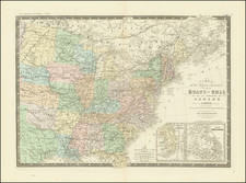
![The United States of America Confirmed By Treaty 1783 [shows Franklinia] By Robert Wilkinson](https://storage.googleapis.com/raremaps/img/small/84491.jpg)


|
||

|

|
|

|
Highly detailed map of the United States, featuring the State of Franklin.
The map shows a number of early transitional boundaries, including a massive Western Territory (the Old Northwest, pre-dating Ohio), New Iberia and Georgia extending to the Mississippi River. Indiana is also shown above Western Virginia.
The history of Franklinia is a fascinating one. In the latter part of the 18th Century, the settlers in Western North Carolina and Eastern Tennessee decided that because of poor representation in State Government, they needed to form a state of their own. A government was formed and initial organizational meetings conducted, but the breakaway state was quickly quelled by the North Carolina authorities, although not before the State of Franklinia began appearing on a number of English maps during the period. Ben Franklin himself responded that while he was honored by the decision to name a state after him, he was not able to relocate.
Robert Wilkinson was active in London as a cartographic publisher from 1785 to 1825. He produced a number of nice works, including a General Atlas and a re-issuance of Bowen & Kitchen's English Atlas, along with excellent large format separate maps.
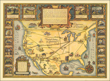
![[Hand Drawn School Girl Map] United States](https://storage.googleapis.com/raremaps/img/small/67904.jpg)