|
||

|

|
|

|
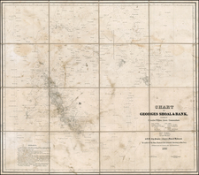
Exceedingly rare early commercial sea chart dedicated to George Washington, published by John Hamilton Moore, published in London in 1792.
The present map was not only dedicated to Washington, Washington in return penned the following note:
To John Hamilton Moore
Philadelphia December 2, 1792
Sir: I have the pleasure to receive a few days ago, the two elegant Sea Charts of the Sea Coast of North America, which you had the goodness to send, and the politeness to dedicate to me.
It is unnecessary for me to make any comment upon the utility of such works when executed by person of ability. The discerning part of mankind will always venerate the promoters of science wheresoever they may be found and in this instance the many who may be benefited by your useful Charts will not forget for whom they owe that advantage. At present premit me to offer my best thanks and acknowledgements to you for this mark of attention, and to assure you that I shall always feel interested in the welfare of those who may promote the cause of science and humanity by laudable exertions. I am etc.
Go: Washington
A further letter referencing the delivery of the charts provides:
Tobias Lear to John Lamb
Philadelphia December 4: 1792.
I was this day honored with your letter of the 30th ultimo, enclosing one for Mrs. Washington, the receipt of which she requests me to acknowledge, and beg your acceptance of her best thanks for the nuts and Apples which you have had the politeness to send to her, & which have come safe to hand.
The Box, which was at the same time sent to the President, and which you mention to have arrived from London in the Ship Betsy, contained two Charts of the Sea-Coast of North America, sent to the President for his acceptance by John Hamilton Moore, Esqr. of London, the executor of them. No account of the price of these Charts was sent and as I do not know of any of the same kind being imported or sold here I cannot form an opinion of their cost; but if it can be hereafter ascertained by any means you shall receive an acct of it. I have the honor to be very respectfully, Sir, Your most Obedt Sert
Tobias Lear.
Founders on line notes that
The two charts that the British hydrographer John Hamilton Moore sent GW were a Chart of Navigation from the Gulf of Honda to Philadelphia and a Chart to Bay of Fundy. Both were in GW's library at the time of his death (see Griffin, Boston Athenæum Washington Collection, 561).
Moore was one of the earliest blue back chart publishers working in London. The present chart was published July 12th, 1792, by John Hamilton Moore, Chartseller to his Royal Highness the Duke of Clarence (Prince William, 1st Duke of Clarence and St Andrews (1765-1837), third son of George III, acceded in 1830 as William IV), and her Serene Highness the Empress of all the Russias (Catherine the Great).
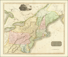
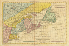
The map is one of a pair of maps published by Moore, the second being a chart of Canada and Newfoundland, published in 1791, entitled:
A New and Correct Chart of North America From the Island of Bellisle, to Cape Cod Drawn from the latest Marine Journals & Surveys, Regulated and Ascertained by Astronomical Observations, by John Hamilton Moore, Hydrographer & Chartseller to his Royal Highness to the Duke of Clarence
The chart is of the utmost rarity. We locate only the examples at the Biblioteca Nacional de España.
![[ American Revolution - Satirical Warning To Dutch Commerce ] Den Door List en Geweld Aangevallen Leeuw.](https://storage.googleapis.com/raremaps/img/small/99580.jpg)