|
||

|

|
|

|
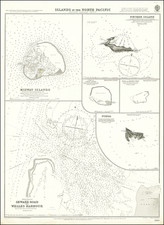
Fine example of this striking view showing La Perouse's ships anchored off the coast of Maui, near Wailea, at what is now called La Perouse Bay, which is the earliest large format view showing the island of Maui.
La Perouse Bay is located south of the town of Wailea-Makena, across the channel from the Island of Kahoolawe. The bay's Hawaiian name is Keone'o'io. La Perouse's ship is surrounded by native outriggers, with what appears to be two thriving settlements along the shoreline. The island at the right is Molokini.
As soon as news of the British discovery of Hawaii reached Paris, Louis XIV immediately dispatched a French expedition under the command of La Perouse, to ascertain the importance of these islands. Nothing of note came from this voyage in terms of Hawaii, La-Perouse in fact only spent 24 hours at Maui. However, an excellent chart was produced, along with this fantastic view. La Perouse surveyed and mapped this area during his brief stop at the southern cape of Maui.
La Perouse set sail from France in 1785, to continue the discoveries of Captain Cook. He was shipwrecked in 1788 but his narrative, maps, and views survived and were published in 1797.
![[Hawaii] Carte des parties des Iles Sandwich . . . 1786 [with] Carte des Iles Sandwich . . .](https://storage.googleapis.com/raremaps/img/small/89351.jpg)