|
||

|

|
|

|
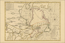
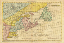
Early state of this rare engraved chart of the region centered on Cape Ann and Ipswich Bay, published by Joseph Frederick Wallet Des Barres on May 6, 1776.
De Barres' chart is without question the finest and most detailed chart of this region, meticulously compiled over a series of years immediately prior to the American Revolution.
The detail within Des Barres' chart is quite remarkable, showing both traditional navigational detail, including shoals and soundings, as well as significant topographical details on land, including the locations of towns, roads, rivers, buildings and farms.
The present example would appear to be the first finished state of the map, although we note an earlier edition which seems to be more in the nature of a proof state in the Library of Congress: www.loc.gov/item/77692980/
The ship's captain responsble for the survey of this region was Herny Mowat. Samuel Holland, the surveyor responsible for this chart, was paired with Mowat. In 1764, Lieutenant Mowat was given command of the 16-gun sloop HMS Canceaux. Canceaux conducted a hydrographic survey of the coast of North America from the estuary of the Saint Lawrence River to Boston, where Mowatt and Holland operated for the next 11 years, gathering survey information and later utilizing his knowledge of the region prior to and at the outset of the American Revolution, to defend Loyalist interests and attack Colonial rebels. Holland's work was hampered by Mowat, who was often "off chasing smugglers." Holland expressed regular disappointment with the lack of accurate soundings on the maps he produced. The survey took far longer than Holland projected, and he was still at work on the surveys in the colonies at the outbreak of the American Revolution in 1775.
Mowat and Holland began their work on the region depicted on this chart in the fall of 1773, following the completion of the survey of Maine, and it was completed over the next several months, with Holland focused on the area south of Cape Ann by the Spring of 1774. By this time, the troubles within the Colonies were growing more urgent and Mowat's attention was increasingly shifted toward military duties. Following the Boston Tea Party of December 1773, Mowat was ordered by Rear Admiral Montagu, to Boston, along with all other British Ships. Despite this divided duty, the survey continued and Holland had by December 1774 advanced the survey to Newport, Rhode Island.
Mowat was ordered to Portsmouth, New Hampshire, in December, 1774, to protect military supplies at Fort William and Mary. Paul Revere alerted the local militia of rumored British seizure of munitions there. Gunpowder was removed from the fort by patriots before Mowat arrived, and a colonial maritime plot ran Canceaux aground in the Piscataqua River estuary. It was several days before the tide refloated Canceaux.
Mowat would later patrol the New England coast for smugglers until ordered to Falmouth (present-day Portland, Maine) in March, 1775, to assist a loyalist shipbuilder who was attempting to defy the Continental Association boycott on goods manufactured in Great Britain. Mowat was temporarily taken prisoner by militia from Brunswick, Maine, during Thompson's War, a few weeks after the battles of Lexington and Concord. Canceaux resumed coastal patrols after Falmouth loyalists negotiated Mowat's release.
Selected specifically for his intimate knowledge of the region, Mowat was ordered to undertake a punitive mission following the battle of Machias to "chastize" the seaports of Marblehead, Salem, Gloucester, Ipswich, Newburyport, Portsmouth, Saco, Falmouth, and Machias. Mowat left Boston aboard Canceaux on October 6, 1775, with the 20-gun ship Cat, the 12-gun schooner HMS Halifax, the bomb sloop HMS Spitfire, and the supply ship HMS Symmetry. Mowat oversaw the 9-hour bombardment and burning of Falmouth on October 18, 1775.
By September 1775, the command overseeing the Survey work was becoming increasingly concerned with Holland's safety and the security of his work and by letter of September 12,1775, he was ordered to return to England by Admiral Graves and by October 1775, his maps and drawings had been sent to London.
Joseph Frederick Wallet Des Barres was born in Switzerland, where his Huguenot ancestors had fled following the repeal of the Edict of Nantes. He studied under the great mathematician Daniel Bernoulli at the University of Basel, before immigrating to Britain, where he trained at the Royal Military College, Woolwich. Upon the outbreak of hostilities with France in 1756, he joined the British Royal American Regiment as a military engineer. He came to the attention of General James Wolfe, who appointed him to join his personal detail. During this period he also worked with the legendary future explorer James Cook, on a monumental chart of the St. Lawrence River.
Upon the conclusion of the Seven Years War, Britain's empire in North America was greatly expanded, and this required the creation of a master atlas featuring new and accurate sea charts for use by the Royal Navy. Des Barres was enlisted to survey the coastlines of Nova Scotia, Newfoundland, and the Gulf of St. Lawrence. With these extremely accurate surveys in hand, Des Barres returned to London in 1774, where the Royal Navy charged him with the Herculean task of producing the atlas. He was gradually forwarded the manuscripts of numerous advanced surveys conducted by British cartographers in the American Colonies, Jamaica and Cuba, of which the present map is based on the work of Samuel Holland, conducted in the 1760s. The result was The Atlantic Neptune, which became the most celebrated sea atlas of its era, containing the first systematic survey of the east coast of North America. Des Barres's synergy of great empirical accuracy with the peerless artistic virtue of his aquatint views, created a work that "has been described as the most splendid collection of charts, plates and views ever published" ( National Maritime Museum Catalogue).
The Neptune eventually consisted of four volumes, and Des Barres's dedication to the project was so strong, that often at his own expense, he continually updated and added new charts and views to various editions until 1784, producing over 250 charts and views, many appearing in several variations. All of these charts were immensely detailed, featuring both hydrographical and topographical information, such that in many cases they remained the most authoritative maps of the regions covered for several decades. Following the completion of The Neptune, Des Barres returned to Canada, where he remained for a further forty years, becoming a senior political figure and a wealthy land owner, living to the advanced age of 103.
Joseph Frederick Wallet Des Barres (1721-1824) was born in either Paris or Basel, Switzerland, to a Hugueont family. He studied under the great mathematician Daniel Bernoulli at the University of Basel before immigrating to Britain, where he trained at the Royal Military College, Woolwich.
Upon the outbreak of hostilities with France in 1756, he joined the British Royal American Regiment as a military engineer. He came to the attention of General James Wolfe, who was impressed with his charting ability. During this period, he also worked with the legendary future explorer, James Cook, on a monumental chart of the St. Lawrence River.
Des Barres is best known for the Atlantic Neptune, was a remarkable, multi-volume set of sea charts and coastal views prepared from recent surveys, some of which were overseen by Des Barres in Nova Scotia after the Seven Years’ War. The maps, charts, and views were prepared under the supervision of Des Barres and employed as many as twenty engravers and assistants. They were produced over the course of a decade, from 1774 to 1784, in time to be used by the Royal Navy in the American Revolution.
After the Revolution, Loyalists were resettled throughout Canada. As part of this process, a new colony was created by separating Cape Breton from Nova Scotia. Des Barres, who already owned extensive lands in the Maritimes, served as lieutenant governor of Cape Breton Island from 1784 to 1787. He later served as governor of Prince Edward Island from 1804-1812.
Des Barres lived an exceptionally long life, even by today's standards, finally dying at age 102. Des Barres' funeral was held at St. George's Round Church in 1824 and he is buried in Halifax.