|
||

|

|
|

|
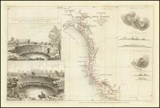
Highly detailed working sea chart of the area between Beecroft Head in the south and Port Jackson in the north, first published by the British Admiralty in 1869, with major revisions up to 1885.
The finely detailed chart reflects the revisions of the Admiralty over a number of years and also includes a coastal profile view and two inset plans of Wollongong Harbor and Kiama Harbor.
John Coode, the former owner of the chart, submitted a document entitled Report on Wollongong Harbour, by Sir John Coode in 1895, and was responsible for the early development of the Harbor.
The Wollongong Harbour Trust was established by Wollongong Harbour Trust Act 1889 and was assented to on 30 September 1889, to commence on 1 October 1889.
The purpose of the Act was to provide for the improvement, management, and regulation of the port of Wollongong and certain portions of the Tom Thumb Lagoon, and for other purposes connected therewith. Under Part one of the Act, the Harbour Trust Commission was constituted as a body corporate consisting of 12 members, known as "The Wollongong Harbour Trust Commissioners". The Trust was in charge to take, purchase, sell lease, and hold lands, tenements, and hereditaments, goods chattels and other property, for any of the purposes of the Act and subject of the provisions of the Act.
The Commissioners were responsible for the appointment and control of the Harbour Master and his assistants. They also appointed officers such as a secretary, treasurer, clerks, engineers, surveyors and collectors to enable them to carry out the provisions of the Act. The major responsibilities of the Commissioners were the management of and control of the port of Wollongong and of the shipping, lightships, buoys, beacons, moorings, wharves, docks, piers, jetties, ferries, landing-stages, slips or platforms, light-houses, and the preservation and improvement of the port generally. There were some specific duties related to the excavation and dredging of the port and the undertaking of certain other works for the protection of shipping and the promotion of trade. The Commissioners also were able to impose various license fees, tolls, rates and charges, including tonnage rates, and make regulations accordingly.
On December 2, 1895 the Wollongong Harbour Trust Commission was dissolved by the proclamation, and the Governor took control of its properties and responsibilities.
The chart was previously owned by Sir John Coode, founding member of the engineering firm of Coode Matthews, Fitzmaurice & Wilson, of 9 Victoria Street in London. In the late 19th and early 20th Century, Coode Matthews was the engineering firm which had charge of the harbor at Dover, along with the harbors at Colombo and Singapore, and were consulting engineers to the Colonial Crown Agents for a number of other British Colonial harbors, including major projects throughout Australia.
Sir John Coode (1816-1892) has been described as the most distinguished harbor engineer of the nineteenth century. He was in charge of the Portland Harbor works in 1856-72. The most famous colonial works for which he was responsible are the harbors of Table Bay and Colombo. In 1849, he was elected a member of the Institute of Civil Engineers and was president from May 1889 to May 1891. He was knighted in 1872 and appointed K.C.M.G. in 1886. He served on the International Commission of the Suez Canal in 1884-92. He was also an active member of the Royal Colonial Institute, and chairman of the Colonial and Continental Church Society.
Coode first visited Australia in 1878, when he was brought out by the Melbourne Harbor Trust to report on works for improving the port. Coode recommended improvement of the existing channel in preference to the direct canal advocated by many local authorities. His recommendations form the foundation for the modern port of Melbourne. Coode was then retained by the Australian government to report on other harbors. His earliest work resulted in recommendations and improvements of Portland Harbor, Geelong, Warrnambool and Port Fairy, in South Australia. Coode also reported on navigation of the Murray River mouth.
In 1885, Coode revisited Australia and examined harbors and river mouths from Fremantle round the southern and eastern coasts, to the Gulf of Carpentaria. He reported from London in 1887-88 to the New South Wales government on the Clarence River, where he recommended the building of two moles or piers to act as breakwaters and training banks, and the removal of the rocky reef across the entrance to provide a fixed navigable entrance and reduce damage from floods and tides. At Richmond River, he recommended breakwaters and training banks to neutralize the shifting character of the river entrance. These two reports were put into effect and helped to develop the trade of rich agricultural hinterlands. At Lake Macquarie, to give better access to the collieries, Coode recommended improvement of the channel connecting the lake to the sea. In his Macleay River report he recommended two breakwaters and training banks to regulate the river entrance.
In 1887 Coode made two reports for the Queensland government; both were carried out. At Mackay, he recommended extensive training banks and the dredging of a continuous deepwater channel from the entrance of the Pioneer River up to the town. For the port of Townsville, he proposed breakwaters and dredging operations. In the same year Coode made two reports for Western Australia. He chose a site for Fremantle Harbour and reported on harbour works, but the plan was rejected. At Geraldton, he recommended a jetty with railways and warehouses to increase accommodation for loading and discharging ships. In South Australia, after personal inspection, he recommended an outer harbor for Port Adelaide.
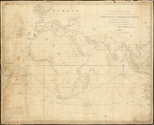
The British Admiralty has produced nautical charts since 1795 under the auspices of the United Kingdom Hydrographic Office (HO). Its main task was to provide the Royal Navy with navigational products and service, but since 1821 it has also sold charts to the public.
In 1795, King George III appointed Alexander Dalrymple, a pedantic geographer, to consolidate, catalogue, and improve the Royal Navy’s charts. He produced the first chart as the Hydrographer to the Admiralty in 1802. Dalrymple, known for his sticky personality, served until his death in 1808, when he was succeeded by Captain Thomas Hurd. The HO has been run by naval officers ever since.
Hurd professionalized the office and increased its efficiency. He was succeeded by the Arctic explorer Captain William Parry in 1823. By 1825, the HO was offering over seven hundred charts and views for sale. Under Parry, the HO also began to participate in exploratory expeditions. The first was a joint French-Spanish-British trip to the South Atlantic, a voyage organized in part by the Royal Society of London.
In 1829, Rear-Admiral Sir Francis Beaufort was appointed Hydrographer Royal. Under his management, the HO introduced the wind force scale named for him, as well as began issuing official tide tables (1833). It was under Beaufort that HMS Beagle completed several surveying missions, including its most famous voyage commanded by Captain FitzRoy with Charles Darwin onboard. When Beaufort retired in 1855, the HO had nearly two thousand charts in its catalog.
Later in the nineteenth century, the HO supported the Challenger expedition, which is credited with helping to found the discipline of oceanography. The HO participated in the International Meridian Conference which decided on the Greenwich Meridian as the Prime Meridian. Regulation and standardization of oceanic and navigational measures continued into the twentieth century, with the HO participating at the first International Hydrographic Organization meeting in 1921.
During World War II, the HO chart making facility moved to Taunton, the first purpose-built building it ever inhabited. In 1953, the first purpose-built survey ship went to sea, the HMS Vidal. Today, there is an entire class of survey vessels that make up the Royal Navy’s Hydrographic Squadron. The HO began to computerize their charts in the late 1960s and early 1970s. In 1968, the compilation staff also came to Taunton, and the HO continues to work from there today.
![[ New South Wales Electors in 1871 ] Map Shewing Roads & Postal Stations in New South Wales Prepared for the Use of the Post Office Department](https://storage.googleapis.com/raremaps/img/small/88237.jpg)