


|
||

|

|
|

|
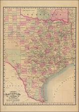
Fine example of Cram's Railroad & Township Map of Texas, one of the rarest of the earliest large format maps to illustrate the railroad system in Texas..
Cram's map of Texas went through several variant states and titles between 1875 and 1879, making the history of the map somewhat difficult to ascertain, except upon closer inspection. There are at least 3 early states of the map. The earliest we have identified, bearing the same title, was issued in 1875. The title is in the Gulf of Mexico and the map is narrower than the present map, but would appear to be the same plate. A second edition, which is wider and encompasses all of Indian Territory, was issued in both atlas and pocket map format in 1876 under the title Cram's New Rail Road & County Map of Texas. Showing Latest Government Sureys &c &c. The title remains in the Gulf of Mexico. The final state (offered here), is the same width as the 1876 map, but only includes a portion of Indian Territory. The title has been moved into Cahahuila and a number of Western Counties have been added, among other noteworthy changes. However, the plate would appear to be almost certainly the same plate as the 1876 map and apparently the 1875 as well. This last edition also includes a number and letter key on the sides and text on the verso, including census information by county.
Cram's map of Texas is constructed on a very large scale and shows towns, counties, railroads, proposed railroads, stations and many other early features. The massive Territory of Young and Territory of Bexar have been replaced by oversized Green and Crockett Counties and a number of smaller counties.
We previously offered the 1876 map in wall map format in 2006. The map more commonly appears in pocket map format.
It has been opined by some commentators that the map was possibly inspired by E. H. Ross ( Ross' New Connected County & Railroad Map of Texas and Indian Territory, issues in 1871, 1872, and 1873).
George F. Cram (1842-1928), or George Franklin Cram, was an American mapmaker and businessman. During the Civil War, Cram served under General William Tecumseh Sherman and participated in his March to the Sea. His letters of that time are now important sources for historians of the Civil War. In 1867, Cram and his uncle, Rufus Blanchard, began the company known by their names in Evanston, Illinois.
Two years later, Cram became sole proprietor and the company was henceforth known as George F. Cram Co. Specializing in atlases, Cram was one of the first American companies to publish a world atlas. One of their most famous products was the Unrivaled Atlas of the World, in print from the 1880s to the 1950s.
Cram died in 1928, seven years after he had merged the business with that of a customer, E.A. Peterson. The new company still bore Cram’s name. Four years later, the Cram Company began to make globes, a branch of the business that would continue until 2012, when the company ceased to operate. For the final several decades of the company’s existence it was controlled by the Douthit family, who sold it just before the company was shuttered.
![(Mexican War) [ Proposed United States - Mexico Military Border - January 1848 ]](https://storage.googleapis.com/raremaps/img/small/99246.jpg)
![[ New Mexico - West Texas ] Estacaco Plain (406) World Aeronautical Chart](https://storage.googleapis.com/raremaps/img/small/96896.jpg)
