The item illustrated and described below is sold, but we
have another example in stock. To view the example which
is currently being offered for sale, click the
"View Details" button below.


|
||

|

|
|

|
Stock# 3934
Description
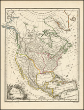
One of the first maps to show the details of Lewis & Clark's expedition. Excellent well researched map of North America. In addition to the Lewis & Clark details, it includes up to date information in Alaska and the NW Coast, and throughout the Missouri and Mississippi Valleys. Malte-Brun went to great lengths to insure that this fine little work reflected the best in contemporary cartographic detail. Ironically, it is also the earliest recorded map to show a river running from San Francisco to the Great Salt Lake (Teguayo), a myth which persisted for the next 20 years. An interesting and historically important map.
![[The Rarest State] Americae Sive Novi Orbis Nova Descriptio](https://storage.googleapis.com/raremaps/img/small/80521.jpg)
![Amerique Septentrionale divisee en Ses Principales parties . . . . 1692 [California as an Island]](https://storage.googleapis.com/raremaps/img/small/95812.jpg)
![[ Trans-Atlantic Cable ] Amerique Septentrionale avec l'indication des Principaux Courants marins d'Amerique en Europe](https://storage.googleapis.com/raremaps/img/small/98084.jpg)