


|
||

|

|
|

|
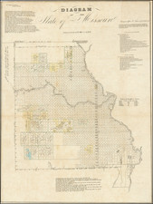
Fine example of this scarce early map of Missouri, published by the General Land Office.
The map identifies the status of the Township Surveys in Missouri, along with unsurveyed areas. It includes a strip in the northwest which was "Country recently added to the State of Missouri by the Act of Congress of the 7th of June 1836" and a strip at the top which had previously been Indian Lands.
At the time of Missouri's admission as a state in 1820, the western border of Missouri was a straight line from Iowa to Arkansas based on the confluence of the Kaw River with the Missouri River in the Kansas City West Bottoms. Land in what is now northwest Missouri was deeded to the Iowa (tribe) and the combined Sac (tribe) and Fox (tribe). Following encroachments on the land by white settlers (most notably Joseph Robidoux), William Clark persuaded the tribes to agree to give up their land in exchange for $7,500 in the 1836 Platte Purchase. The land purchase was ratified by Congress in 1837.
A number of township squares are shaded in yellow, green outline and blue, identifying the names of a number of early land districts and "Contracts."
An important early map of Missouri.

![[ Map of the Mississippi River ]](https://storage.googleapis.com/raremaps/img/small/99811.jpg)