|
||

|

|
|

|
Fine example of this seminal map of the West.
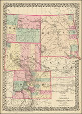
Mitchell's map shows the West shortly after the start of the Gold Rush but before the creation of Arizona, Nevada, Colorado, Idaho, Wyoming and Montana.
The map shows Spanish Trail, Cooke's Wagon Route, Kearney's Route, Lewis & Clarke's Canoe Route, Oregon Route, early roads, towns, Indian Tribes, mining claims, mountains, rivers, etc.
No Lake Tahoe appears but a massive Tule Lake dominates Southern California.
Only very early California Counties shown. For example, Ventura and San Bernardino County do not yet appear.
Pre-Gadsden purchase border with Mexico. Early forts located, especially in Oregon Territory. Nice topographical detail after Fremont, although still very conjectural in the Great Basin. The Southwest is dominated by several massive counties which extend the width of Utah Territory and New Mexico Territory. Only the western counties of Oregon & Washington appear.
A gorgeous full color example of this marvelous map.
![[ Cabo San Lucas, Southern Baja ] Delineatio Nova Et Vera Partis Australis Novi Mexici, cum Australi Parte Insulae Californiae Saeculo Priori ab Hispnis Detectae.](https://storage.googleapis.com/raremaps/img/small/95666.jpg)
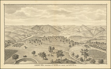
![[Fruit Crate Label Advertising Map] Star of California Brand](https://storage.googleapis.com/raremaps/img/small/41396.jpg)