


|
||

|

|
|

|
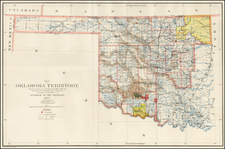
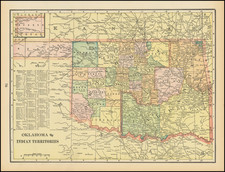
Detailed map of Oklahoma and Indian Territories, showing towns, railroads, railroad stations, township surveys, counties, Indian Tribal Reservations, etc.
The Oklahoma Organic Act of 1890 created the Oklahoma Territory out of the Unassigned Lands and the area known as No Man's Land, placing Oklahoma as the western section of what had formerly been called Indian Territory alone.
In 1893, the government purchased the rights to settle the Cherokee Outlet, or Cherokee Strip, from the Cherokee Nation. The Cherokee Outlet was part of the lands ceded to the government in the 1866 treaty, but the Cherokees retained access to the area and had leased it to several Chicago meat-packing plants for huge cattle ranches. The Cherokee Strip was opened to settlement by land run in 1894. Also, in 1893, Congress set up the Dawes Commission to negotiate agreements with each of the Five Civilized Tribes for the allotment of tribal lands to individual Indians. Finally, the Curtis Act of 1898 abolished tribal jurisdiction over all of Indian Territory.
In 1902, the leaders of Indian Territory sought to become their own state, to be named Sequoyah. They held a convention in Eufaula, consisting of representatives from the Cherokee, Choctaw, Chickasaw, Muscogee (Creek) and Seminole tribes, known as the Five Civilized Tribes. They met again the next year to establish a constitutional convention. The Sequoyah Constitutional Convention met in Muskogee, on August 21, 1905. General Pleasant Porter, Principal Chief of the Muscogee Creek Nation, was selected as president of the convention.
The convention drafted the constitution, established an organizational plan for a government, outlined proposed county designations in the new state and elected delegates to go to the United States Congress to petition for statehood. If this had happened, the State of Sequoyah would have been the first state to have a Native American majority population. The convention's proposals were overwhelmingly endorsed by the residents of Indian Territory in a referendum election in 1905. The U.S. government, however, reacted coolly to the idea of Indian Territory and Oklahoma Territory becoming separate states; they preferred to have them share a singular state.
William H. Murray, had been appointed as the Chickasaw representative to the convention. Murray predicted the Sequoyah statehood plan would not succeed in Washington, D.C.. He suggested that if the attempt failed, the Indian Territory would work with the Oklahoma Territory to become one state. President Theodore Roosevelt and Congress turned down the Indian Territory proposal.
Seeing an opportunity for statehood, Murray and Haskell proposed another convention for the combined territories to be named Oklahoma. In 1906, the Oklahoma Enabling Act was passed by the U.S. Congress and approved by President Roosevelt. The act established several specific requirements for the proposed constitution. Using the constitution from the Sequoyah convention as a basis (and the majority) of the new state constitution, Haskell and Murray returned to Washington with the proposal for statehood. On November 16, 1907, President Theodore Roosevelt signed the proclamation establishing Oklahoma as the nation's 46th state.
George F. Cram (1842-1928), or George Franklin Cram, was an American mapmaker and businessman. During the Civil War, Cram served under General William Tecumseh Sherman and participated in his March to the Sea. His letters of that time are now important sources for historians of the Civil War. In 1867, Cram and his uncle, Rufus Blanchard, began the company known by their names in Evanston, Illinois.
Two years later, Cram became sole proprietor and the company was henceforth known as George F. Cram Co. Specializing in atlases, Cram was one of the first American companies to publish a world atlas. One of their most famous products was the Unrivaled Atlas of the World, in print from the 1880s to the 1950s.
Cram died in 1928, seven years after he had merged the business with that of a customer, E.A. Peterson. The new company still bore Cram’s name. Four years later, the Cram Company began to make globes, a branch of the business that would continue until 2012, when the company ceased to operate. For the final several decades of the company’s existence it was controlled by the Douthit family, who sold it just before the company was shuttered.
![Mapa et tierra q[u]e yos pedro Vial taigo transitau en St. Tafee este dia 18 de Octubre de La ao 1787](https://storage.googleapis.com/raremaps/img/small/3645.jpg)

![[ Republic of Texas ] Central America II. Including Texas, California and the Northern States of Mexico](https://storage.googleapis.com/raremaps/img/small/93534.jpg)