|
||

|

|
|

|
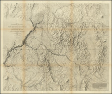
Detailed map of the Black Hills Region of western South Dakota and Eastern Wyoming, between the North Fork and the South Fork of the Cheyenne River, published by Samuel Scott of Custer, South Dakota and printed by E.P. Noll & Co. of Philadelphia.
The map focuses on the topographical details of the region, showing mountains, elevations, rivers, coal mining regions, towns, roads and railroad lines. Major cities include Belle Fourche, Deadwood, Sturgis, Rapid City, Custer, Newcastle, Buffalo Gap, Hot Springs, etc.
This work has been refered to as "the first book on descriptive mineralogy of the Black Hills. Today highly sought after as a Black Hills mining relic" (Loomis). Rumsey notes:
Forty page description of mineral resources and appendix. Very well done map, large scale, without color, and folded into dark burgandy card board covers 19 x11 with "Rocks, Minerals, And Other Resources Of The Golden Black Hills Of South Dakota And Wyoming" printed in silver.
![History of the Expedition under the Command of Captains Lewis and Clark, to the Sources of the Missouri Thence across the Rocky Mountains and Down the River Columbia to the Pacific Ocean, Performed During the Years 1804-5-6 [with map:] Map of Lewis and Clark's Track, Across the Western Portion of North America from the Mississippi to the Pacific Ocean](https://storage.googleapis.com/raremaps/img/small/92506.jpg)