|
||

|

|
|

|
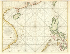
A highly decorative and important 17th Century map of the area now covering China's Jiangsu Province and Shanghai Municipality, by Joan Blaeu, based on the landmark surveys of the Jesuit Missionary Martino Martini.
This beautiful map focuses on the lower Yangtze River and includes what was then Nanjing Province (here called 'Kiangnan'), which includes modern Jiangsu Province and the Shanghai Municipality. Mountains, rivers, lakes and salt marshes are finely engraved, while cities and towns are conveyed by their hierarchy. An elegant title cartouche, framed by rightly dressed Mandarins, graces the lower left corner.
Nanjing, which means "Southern Capital" was one of the Four Ancient Captials of China, having first served as the captial of the Wu Kingdom during the Three Kingdoms Period in 229 AD. During the Ming Dynasty (1368-1644), Nanjing was one of the Chinese Empire's two capitals (along with Beijing) and was one of the most populous cities in the world. During the twillight of the Ming Dynasty, following the fall of Beijing to the Qing Emperor Li Zicheng, in June 1644, the Ming Prince Zhu Yousong was enthroned in Nanjing as the Hongguang Emperor. His brief reign was described by later historians as the first reign of the so-called Southern Ming Dynasty, which survived with decreasingly smaller territory until it was extinguished by the Manchus in the 1660s. During the period that this map was made, the early years of the Qing Dynasty (1644-1911), the Nanjing area was known as Jiangning and served as the seat of government for the Liangjiang Viceroy.
Shanghai was located near where "Changno" is labelled on the map. Shanghai was then a small county town and its rise to become a great port would not occur until the Qing rulers elminated the late Ming's prohibition on offshore sea travel in 1684.
Other notable cities include "Suchou" (Suzhou), then a major city beside Taihu Lake and "Hangchou" (Hangzhou, Zhejiang), which was one of the China's Four Ancient Capitals.
The map is based on the groundbreaking work of Martino Martini (1614-61), a legendary Italian Jesuit missionary and scholar. Martini arrived in Beijing in 1644 just as the Ming Dynasty fell to the Manchurian rebels and remained in the country until 1651. Following in the footsteps of his fellow Italian Jesuit Mateo Ricci, Martini sought out the very best maps and surveys of the Chinese Empire. He compiled a series of maps that were by far the most accurate depictions of China to date. Martini's suite of 17 regional maps was first published by the preeminant Dutch cartographer Joan Blaeu (1598-1673), as the Novus Atlas Sinensis, which accounted for volume 10 of his Atlas Maior (Amsterdam, 1655). Blaeu's arch-rival, Jan Jansson (a.k.a. Janssonius, 1588-1664), issued a competing set of maps based upon Martini's work shortly thereafter. Martini's work was described by the great German geographer Ferdinand von Richthofen, as:
"the most complete geographical description of China that we possess, and through which Martini has become the father of geographical learning on China."
Indeed, even Jean-Baptiste du Halde's Description…de la Chine (Paris, 1735), published 80 years later, did not fully supersede Martini's work.
The present map is from a 1662 edition of the Novus Atlas Sinensis. Blaeu's map is a cornerstone of any collection of maps of the Shanghai-Nanjing corridor.
Willem Janszoon Blaeu (1571-1638) was a prominent Dutch geographer and publisher. Born the son of a herring merchant, Blaeu chose not fish but mathematics and astronomy for his focus. He studied with the famous Danish astronomer Tycho Brahe, with whom he honed his instrument and globe making skills. Blaeu set up shop in Amsterdam, where he sold instruments and globes, published maps, and edited the works of intellectuals like Descartes and Hugo Grotius. In 1635, he released his atlas, Theatrum Orbis Terrarum, sive, Atlas novus.
Willem died in 1638. He had two sons, Cornelis (1610-1648) and Joan (1596-1673). Joan trained as a lawyer, but joined his father’s business rather than practice. After his father’s death, the brothers took over their father’s shop and Joan took on his work as hydrographer to the Dutch East India Company. Later in life, Joan would modify and greatly expand his father’s Atlas novus, eventually releasing his masterpiece, the Atlas maior, between 1662 and 1672.
![[Nepal] Latest Trekking Map North North of Jomsom Jomsom to Mustang](https://storage.googleapis.com/raremaps/img/small/44106.jpg)

![[Shanghai, Hangzhou, Ningbo, Suzhou] Carte du Tche-kiang dressee ar les Missionaires sous la direction de Mgr Guierry de la Congregation de St. Lazare Vicaire Apostque du Tach-Kiang](https://storage.googleapis.com/raremaps/img/small/64426.jpg)
![[China] 古今地舆全圖 / Full Modern and Ancient Map](https://storage.googleapis.com/raremaps/img/small/62437kb.jpg)