


|
||

|

|
|

|
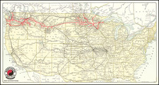
Beautiful example of Melish's map of the United States. Includes notes on Lewis & Clark, a massive Missouri Territory, early Michigan Territory and Northwest Territory. A number of Western Forts are shown in the Mississippi Valey Texas is named, with a badly mislocated Galveston and a handful of other placenames, including Ft. Matagorda. The map shows towns, roads, Indian placenames, river and a handful of early and not always accurate exploration notes. Melish's maps are highly coveted, especially the separately issued versions of the map. this unusual example was entered according to act of Congress 10th July 1818 and Published by Murray Draper Fairman & Co. of Philadelphia. One of the earliest examples of this map which we have seen to date, with Illiniois still pushed off the lake with tortured path to include Chicago. Only the second time we have had this early state of the map, with the previous example being in much lesser condition. A few minor fold splits. Printed on unusualy heavy paper.
John Melish (1771-1822) was the most prominent American mapmaker of his generation, even though his cartographic career lasted only a decade. Melish was born in Scotland; he moved to the West Indies in 1798 and then to the United States in 1806. By 1811, he had settled in Philadelphia and published Travels through the United States of America, in the years 1806 & 1807, and 1809, 1810, & 1811, which was richly illustrated with maps.
Melish created several regional maps of the highest quality, as well as the Military & Topographical Atlas of the United States (Philadelphia, 1813, expanded 1815). The latter work is widely considered to be the finest cartographic publication to come out of the War of 1812.
By far his best-known work is his monumental map of the United States of 1816, Map of the United States with the contiguous British and Spanish Possessions. He began working on the map in 1815 and sent it to Thomas Jefferson for comment in 1816. Jefferson enthusiastically reviewed the map and returned it with his edits. Jefferson later hung an example of the map in the Entrance Hall of Monticello and sent it to associates in Europe.
Melish’s finished product was the first map of the United States to extend to the Pacific Ocean. After its publication in 1816, Melish ensured the map was as up-to-date as possible; it was reissued in 25 known states published between 1816 and 1823. The map captured the then rapidly changing geography of the United States, as well as various boundary disputes, treaties, and expansion.
![Vereinigte Staaten Von Nordamerika [United States of America]](https://storage.googleapis.com/raremaps/img/small/79951.jpg)

![[First State of the Popple Key Sheet] A Map of the British Empire in America with the French and Spanish Settlements adjacent thereto by Hen. Popple.](https://storage.googleapis.com/raremaps/img/small/92714.jpg)