
This item has been sold, but you can enter your email address to be notified if another example becomes available.


|
||

|

|
|

|
Stock# 38356
Description
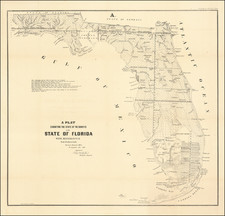
Highly detailed map of Florida, prepared by the Surveyor General of the United States.
This state survey map is drawn on a scale of 18 miles to the inch. It shows the topography, vegetation, towns, cities, forts, rivers, lakes, swamps and many early trails and roads. Most of the state is shown as surveyed with a key designating the extent or the work completed. Area extends to show the keys and to Dry Tortugas Island and Ft. Jefferson, and locates Ft. Lauderdale, Boca Rabones, Key Biscayne, scores of smaller keys and much, much more.
The map is signed in the plate by Francis L. Darcy, Surveyor General.
Condition Description
Narrow left margin, with some loss of neatline.
![[Florida & Bahamas] Amer. Sep. No. 62. Florides et Iles Lucayes](https://storage.googleapis.com/raremaps/img/small/101496.jpg)

![[ Atlas of The United States ] Karte von Amerika](https://storage.googleapis.com/raremaps/img/small/84353mp2.jpg)
![(Tallahassee, Florida / Signed by John Quincy Adams) [Certification of full payment by John Boyd for 79 acres of land in Tallahassee, acquired from the General Land Office]](https://storage.googleapis.com/raremaps/img/small/86625.jpg)
![[Hand Drawn Map] Le Golfe de Mexique avec les Pays Circonvoisins](https://storage.googleapis.com/raremaps/img/small/91580.jpg)