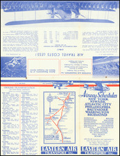
|
||

|

|
|

|
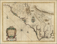
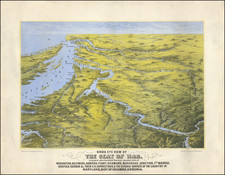
Fine example of the rare first state of William Heather's remarkable sea chart of the coastal regions of the Southeastern United States, from Albemarle Sound, North Carolina to the Palm Beach area of Florida.
This large format sea chart embraces the northern Atlantic Coast of Florida, all of tidelands Georgia and South Carolina and the vast majority of coastal North Carolina. Presented here in its first state, it is one of the rarest and most high-quality maps of the region from its era. The coastlines are very well delineated, based on scientific triangulated surveys, while the seas feature copious hydrographic information, including bathymetric soundings, shoals and ocean currents. The upper portion of the map features highly detailed cartographic insets showcasing major ports, including the entrance to the 'Savannah River', 'Port Royal Sound' (South Carolina), 'Charleston' and the 'Cape Fear River' (North Carolina).
The genealogy of the chart is most fascinating, for it is based on some of the most important and technically impressive surveys conducted in the Americas during the 18th century.
Starting from the south, the coastline of Florida is based on the epic surveys conducted by William Gerard de Brahm (1718-99), from 1765 to 1771. Commissioned by the British Board of Trade following Britain's acquisition of Florida from Spain in 1763, they were the first scientific surveys of Florida and were of such superlative quality that they were not generally superseded for over a century. The details as shown here are derived from Thomas Jefferys' chart, The Peninsula and Gulf of Florida or New Bahama Channel with the Bahama Islands (1775), which was based on De Brahm's work.
Important features include 'St. Augustine' the old capital of Florida (founded in 1565), 'Cape Cannaveral' (Cape Canaveral) and a series of places with particularly English place names, such as 'Hillsborough' and 'Grenville' inlets, named by De Brahm after important British politicians and land speculators. 'Mosquito Inlet or New Smyrna Entrance' marks the location of 'New Smyrna', which was the largest European settlement in Florida from 1768 to 1778, run by a tyrannical Scotsman who enslaved Greek and Minorcan migrants. During the time that this chart was made, Florida had reverted to Spanish control (in 1784) and would not become American territory until 1819.
Of great importance is the labeling of the 'Gulf Stream', the powerful ocean current that sweeps up the east coast of Florida from the Caribbean and which moves quickly across the Atlantic to Europe. While Benjamin Franklin had been the first to delineate the current on a map, in 1769, De Brahm was the first person to scientifically chart its course, with his map first being published in 1772.
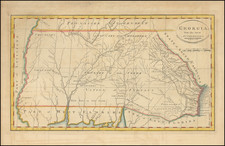
Further north, moving into Georgia, the basic template of the coastline is based on William Gerard de Brahm's A Map of South Carolina And a Part of Georgia (1757), which follows his work done as the Surveyor General for both provinces. The nautical information seems to have been largely taken from surveys done by the Royal Navy while the British occupied Georgia from 1779 to 1783, during the American Revolution.
The mapping of the Carolinas is largely based on Henry Mouzon's An accurate Map of North and South Carolina, published by Thomas Jefferys in 1775. Mouzon, in turn relied heavily on De Brahm's 1757 map for his depiction of South Carolina. Much of the nautical information shown here is derived from a variety of surveys conducted by the Royal Navy, between 1729 and 1783.
Of the cartographic insets along the top of the map, the charts of the 'Savannah River' and 'Port Royal Sound' are based on manuscript charts executed by Captain John Gasgoigne in 1729. While his surveys were, by the time that this map was made, 70 years old, they were exceedingly well done and were not superseded until well into the 19th century.
The chart of Charleston is generally based on Royal Navy charts made during the successful British attack upon the city in 1780 but feature some more recent embellishments. The chart of the Cape Fear River, the gateway to North Carolina's main ports of Brunswick and Wilmington, is based on a map done by Captain John Collet, who was the commander of Fort Johnston, located near the mouth of the Cape Fear River, in the days leading up to the American Revolution. Collet is most famous for his A Compleat Map of North Carolina from an actual survey (1770).
Among the late 18th century sea charts of the region, in terms of its size and accuracy, Heather's chart far surpasses contemporary American charts by Matthew Clark, John Norman and Jonathan Price & John Strother. Among the post-Revolutionary War sea charts of the southeastern United States, only the rare 1784 Gerard Hulst Van Keulen and 1785 David Steel charts provide comparable detail, size and accuracy.
William Heather (fl. 1765-1812) was among the most important English Sea Chart publishers of the 18th Century. Heather began his business in 1765 as a publisher and dealer of sea charts and nautical instruments near the offices of the East India Company, under the sign of the "Little Midshipman," where he succeeded the celebrated firm of Mount & Page. The business was later to become known as "the Naval Academy" and "Navigation Warehouse" and was referenced by Charles Dickens in Dombey and Son. In 1768, the business became "Heather & Williams" and remained so until Heather's death in 1812, when John William Norie, who had joined Heather in 1797 at age 25, became the proprietor.
The present example is the rare first state of the chart, with the Heather and Williams imprint and dated July 12th 1799, running along the bottom margin of the chart. Later editions lack the Heather and Williams imprint.
The present edition of the chart is very rare, we are not aware of any other examples appearing on the market during the last 25 years.