|
||

|

|
|

|
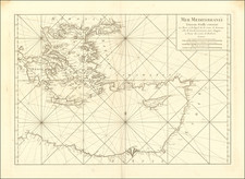
Fine early view of part of the south coast of the Peloponnese, showing the Battle of Modon (1500), between the Ottoman Empire and Venetian Republic.
This rare map of the southern Peloponnese, shows the region which includes Pylos (Navarrin), Methoni (Modon) to Koroni (Coron). The map shows graphic represenation of the Battle of Modon, between the Venetian Republic (shown as Christians on the map) and the Ottoman Empire (Turks). The Venetian and Ottoman fleets and respective armies are shown, with the focal point of the battle being the fortified town and tower of Modon at the center, with the Bay of Navarino to the left, also a site of conflict.
Pylos, Modon and Coron were the sites of an important battle between the Turks and the Venetians at the end of the 15th Century. The Battle of Modon took place in August 1500 during the war of 1499-1503 between the Ottoman Empire and the Republic of Venice. The Ottomans, who had won the Battle of Zonchio (First Battle of Lepanto / Battle of Sapienza) the previous year, were again victorious under Admiral Kemal Reis.
In December 1499, the Venetians attacked Lepanto with the hope of regaining the territories which they lost with the Battle of Zonchio. Kemal Reis set sail from Cefalonia and retook Lepanto from the Venetians. He stayed in Lepanto between April and May 1500, where his ships were repaired by an army of 15,000 Ottoman craftsmen who were brought from the area. From there Kemal Reis set sail and bombarded the Venetian ports on the island of Corfu and in August 1500, he once again defeated the Venetian fleet. He bombarded the fortress of Modon from the sea and captured the town. He later engaged with the Venetian fleet off the coast of Coron and captured the town along with a Venetian brigantine. From there he sailed towards the Island of Sapientza (Sapienza), and sank the Venetian galley "Lezza". In September 1500 Kemal Reis assaulted Voiussa and in October he appeared at Cape Santa Maria on the Island of Lefkada before ending the campaign and returning to Constantinople in November.
With the Battle of Modon, the Ottoman fleet and army quickly overwhelmed most of the Venetian possessions in Greece. Modon and Coron, the "two eyes of the Republic", were lost. Ottoman cavalry raids reached Venetian territory in northern Italy and in 1503 Venice again had to seek peace, recognizing the Ottoman gains.
The same area would be the site of an important conflict at about the same time as the publication of this map. Shortly after the Ottoman fleet was defeated at the Naval battle of Naupactos (Lepanto), in 1573, the Turks began construction of a fortress at Pylos (Navarrin on the map), at the foot of Mount Áyios Nikólaos, with the goal of controlling the southern entrance to the bay of Navarino, the largest natural harbor in the region. The fortress (Niokastro), was the second fortification in the region, along with the Palio Navarino (Old Castle), a Frankish castle on the Koryphasion peninsula on the north side of the bay. From 1498 to 1821, Navarino Bay was controlled by the Turks except for two periods (1644-48 and 1686-1715), when it was held by the Venetians. On the present map, the Chasteau de Navarrin on the north side of the bay is shown but the Niokastro (New Castle) is not yet shown.
The map appeared in La Cosmographie Universelle de tout le monde by Nicolas Chesneau and Michel Sonnius, in two volumes in Paris. The French text was written by Francois de Belleforest.
![(Atlas of the Aegean -- Extra Illustrated!) L'Egeo redivivo o' sia chorographia dell' arcipelago, e dello stato primiero, & attuale di quell' isole. . . [The Aegean revived, or the chorography of the archipelago, and of the original and current state of those islands. . .]](https://storage.googleapis.com/raremaps/img/small/93229.jpg)
![[Crete -- Land of Mythical Creatures and Greek Gods] Creta Insula Plerumq; Deum Natalibus., Iovis Incunabulis Sepulchroq: Inclyta: Adventu Europae, Minoe Ree; Pasiphaes et Ariadnae Amoribus; Minotauri Feritate,Fatoqu: Daedali Labryntho et Fuga; Multisq. alijs Famigerata Fabuili. Centum Urbibus Habitata; Quae Prima Ptuit Nauibus Satittis, Prima Litteris jura Iunxit. . . . M DC LXXVI](https://storage.googleapis.com/raremaps/img/small/82040.jpg)
![(Ancient Turkey and Middle East) Tabula Itineris Decies Mille Graecorum Cyro merentium contra fratrem Artaxerxem Regem Persarum [The Retreat of the Ten Thousand Greeks]](https://storage.googleapis.com/raremaps/img/small/89459.jpg)